Filter: Categories of Wisconsin Historical Images
Filter: Subject of Mississippi River
Filter: County of Crawford
Filter: Subject of human settlements
Filter: Categories of Wisconsin Historical Images
Filter: Subject of Mississippi River
Filter: County of Crawford
Filter: Subject of human settlements

| Date: | 1870 |
|---|---|
| Description: | During the War of 1812, the only battle fought in Wisconsin was in Prairie du Chien, in 1814. Made fifty-six years later, this birds eye drawing depicts th... |
| Date: | 1880 |
|---|---|
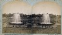
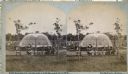
| Description: | Stereograph of the Artesian Well near the intersection of Wisconsin and Minnesota (later renamed Wacouta) Streets. The following is printed on the back of ... |

| Date: | 1884 |
|---|---|
| Description: | Bird's-eye view drawing of the grounds of Villa Louis, the estate of the fur trading Dousman family. After the death of H. Louis Dousman's mother in 1882, ... |
| Date: | 1880 |
|---|---|
| Description: | Stereograph of the Artesian Well near the intersection of Wisconsin and Minnesota (later renamed Wacouta) Streets. The following is printed on the backside... |

| Date: | 1895 |
|---|---|
| Description: | View down road with the Bay State House on the left. Three houses and a barbershop also line the street. A lamppost is in the left foreground. The Mississ... |

| Date: | 09 1962 |
|---|---|
| Description: | The Mississippi River along Highway 35. |

| Date: | 1820 |
|---|---|
| Description: | A manuscript map of Prairie du Chien. |
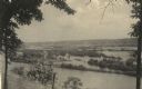
| Date: | 1954 |
|---|---|
| Description: | View from Brisbois Point. Prairie du Chien lies below, and beyond the Mississippi River rise Iowa's hills. |

| Date: | 1836 |
|---|---|
| Description: | Woodcut of Prairie du Chien in 1836. Text at bottom reads: "Prairie du Chien in 1836. From an old cut." |
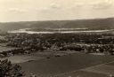
| Date: | 1910 |
|---|---|
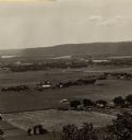
| Description: | Elevated view from Brisbois Bluff of town, Mississippi River, and hills beyond. |
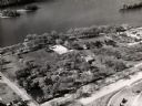
| Date: | 1960 |
|---|---|
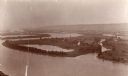
| Description: | Aerial view of Villa Louis on the Mississippi River, and adjacent buildings. |
| Date: | 1905 |
|---|---|
| Description: | View looking toward old Diamond Jo Warehouse, before the bridge was built. Caption reads: "Mississippi River and Prairie du Chien, Wis., from Iowa Side". |
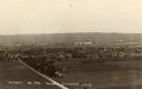
| Date: | 1930 |
|---|---|
| Description: | Elevated view of the north side of town, from high on the bluff. Caption reads: "'Birdseye' No. End Prairie Du Chien, Wis." |
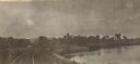
| Date: | 1905 |
|---|---|
| Description: | View along curving railroad tracks towards town, with the river along the right. St. Mary's Academy is among trees in the center. |
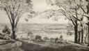
| Date: | 1910 |
|---|---|
| Description: | View from the bluffs in or near McGregor, Iowa. A fence and trees are in the foreground. |
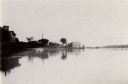
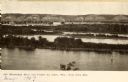
| Date: | 1931 |
|---|---|
| Description: | Mississippi River from the Brisbois Mansion. Left to right: Dousman House Hotel, railroad station, electrical plant smokestack, Diamond Jo warehouse, and a... |

| Date: | 1840 |
|---|---|
| Description: | Fort Crawford (the second site, with buildings of 1829-?), on the east bank of the Mississippi River, about 2 miles above the mouth of the Wisconsin River. |

| Date: | 1821 |
|---|---|
| Description: | A topographical view of the site of Fort Crawford. |
If you didn't find the material you searched for, our Library Reference Staff can help.
Call our reference desk at 608-264-6535 or email us at: