 Filter: Categories of Wisconsin Historical Images
Filter: Subject of Mississippi River
Filter: Creator Name of Vliet, Jesper
Filter: Categories of Wisconsin Historical Images
Filter: Subject of Mississippi River
Filter: Creator Name of Vliet, Jesper
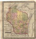
| Date: | 1857 |
|---|---|
| Description: | This map shows drainage, state boundaries, county boundaries, rivers, lakes, township lines, cities, and towns. The Milwaukee & Horicon Road road is indica... |
If you didn't find the material you searched for, our Library Reference Staff can help.
Call our reference desk at 608-264-6535 or email us at: