Filter: Categories of Wisconsin Historical Images
Filter: Subject of Mississippi River
Filter: Creator Name of Unknown
Filter: Year of 1800-1899
Filter: Categories of Wisconsin Historical Images
Filter: Subject of Mississippi River
Filter: Creator Name of Unknown
Filter: Year of 1800-1899

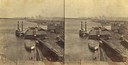
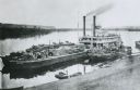
| Date: | 1873 |
|---|---|
| Description: | The harbor, showing the sidewheel packet, "Belle of La Crosse," and the sidewheel ferry "Alex McGregor." Other boats are also seen including two barges loa... |
| Date: | 1858 |
|---|---|
| Description: | Elevated view of the sidewheel packet, Keokuk, at the Winona, Minnesota levee between 1858 and 1866. A barge and railway cars are in the foreground. |

| Date: | 1868 |
|---|---|
| Description: | The sidewheel packet, Keokuk, loaded with passengers beside a barge at a landing. The landing is filled with people and horse-drawn vehicles. The si... |

| Date: | 1872 |
|---|---|
| Description: | The sidewheel packet, Red Wing, in the Mississippi River near Queen's Bluff below Trempealeau, Wisconsin. |

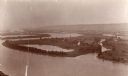
| Date: | 1875 |
|---|---|
| Description: | Aerial view of Alma along Mississippi River, with bluffs along the horizon. |
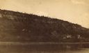
| Date: | 1890 |
|---|---|
| Description: | Mississippi River, with Alma in the distance, a typical river town which flourished in the 1850s. |

| Date: | 1895 |
|---|---|
| Description: | View down road with the Bay State House on the left. Three houses and a barbershop also line the street. A lamppost is in the left foreground. The Mississ... |

| Date: | 1890 |
|---|---|
| Description: | Stereograph of the upper Mississippi River. The text on the photograph reads: "From Whitney's Gallery, St. Paul, Minn." |

| Date: | 1885 |
|---|---|
| Description: | Mississippi River stereograph, with a St. Jacob's Oil building in the distance. |

| Date: | 1814 |
|---|---|
| Description: | Map of the Upper Territories of the United States. |
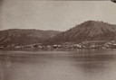
| Date: | 1887 |
|---|---|
| Description: | View over Mississippi River of town on shoreline with bluff in the background. |

| Date: | 1835 |
|---|---|
| Description: | Constructed for the Topographical Bureau [Wash.], 1835. Scale: 16 miles to 1 inch. Map of a portion of the Indian country lying east and west of the Missis... |

| Date: | 1836 |
|---|---|
| Description: | Woodcut of Prairie du Chien in 1836. Text at bottom reads: "Prairie du Chien in 1836. From an old cut." |

| Date: | 1840 |
|---|---|
| Description: | Fort Crawford (the second site, with buildings of 1829-?), on the east bank of the Mississippi River, about 2 miles above the mouth of the Wisconsin River. |

| Date: | 1821 |
|---|---|
| Description: | A topographical view of the site of Fort Crawford. |

| Date: | 1829 |
|---|---|
| Description: | Photoprint of Crawford County lead district map. |
| Date: | 1875 |
|---|---|
| Description: | View down hill towards "Diamond Jo" steamboat docked on the shoreline of the Mississippi River while goods are being loaded onto the steamboat. |
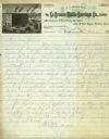
| Date: | 1887 |
|---|---|
| Description: | Letterhead of the La Crosse Wallis Carriage Co., manufacturers of fine family carriages, showing a view of the factory with the Mississippi River in the ba... |

| Date: | 1842 |
|---|---|
| Description: | A map of the Western rivers, a "travellers guide" exhibiting the Mississippi, Missouri, Ohio and Illinois Rivers with principal towns. |
If you didn't find the material you searched for, our Library Reference Staff can help.
Call our reference desk at 608-264-6535 or email us at: