Filter: Categories of Wisconsin Historical Images
Filter: Subject of Mississippi River
Filter: Creator Name of Unknown
Filter: Categories of Wisconsin Historical Images
Filter: Subject of Mississippi River
Filter: Creator Name of Unknown
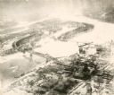
| Date: | 1935 |
|---|---|
| Description: | An aerial view of La Crosse and the Mississippi River with the bridge drawn in to show what the finished product would look like. |

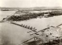
| Date: | 1940 |
|---|---|
| Description: | Aerial view of the bridge spanning the Mississippi River in La Crosse. |

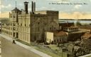
| Date: | 1911 |
|---|---|
| Description: | Elevated view of the John Gund Brewing Company buildings, with the Mississippi River in the background. Caption reads: "John Gund Brewing Co., La Crosse, W... |
| Date: | 1910 |
|---|---|
| Description: | Elevated view of the brewery with the Mississippi River in the background. Caption reads: "G. Heileman Brewing Co., La Crosse, Wis." |

| Date: | 1920 |
|---|---|
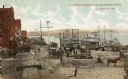
| Description: | View across water toward the Mississippi River front showing Listman's Mills. Caption reads: "River Front and Listman's Mills, La Crosse, Wis." |
| Date: | 1905 |
|---|---|
| Description: | View from the top of a railroad car on railroad tracks along the Mississippi River shoreline. Ships are along the shoreline on the right, and railroad trac... |
| Date: | 1900 |
|---|---|
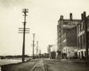
| Description: | View down railroad tracks, with the Mississippi River on the left, and on the right the J.J. Hogan Wholesale Company. |
| Date: | 1910 |
|---|---|
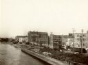
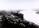
| Description: | Elevated view over the Mississippi River towards the waterfront in La Crosse. |
| Date: | |
|---|---|
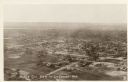
| Description: | Aerial view of La Crosse, with the Mississippi River in the distance. |

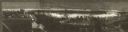
| Date: | 1900 |
|---|---|
| Description: | Elevated view of La Crosse. Caption reads: "Panorama of La Crosse, Wis. from Grand Dad's Bluff." |
| Date: | |
|---|---|
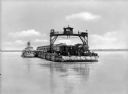
| Description: | View across water toward a railroad train and locomotive on a ferry going across the Mississippi River near New Orleans. |
| Date: | |
|---|---|
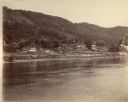
| Description: | View across the river towards buildings along the shoreline in Victory. |
| Date: | 1907 |
|---|---|
| Description: | Elevated view from first peak of Trempealeau, Wisconsin. |

| Date: | 1835 |
|---|---|
| Description: | Constructed for the Topographical Bureau [Wash.], 1835. Scale: 16 miles to 1 inch. Map of a portion of the Indian country lying east and west of the Missis... |

| Date: | 1930 |
|---|---|
| Description: | View of town on opposite shoreline, and piers in the foreground on the right. Taken from the Burlington Railroad bridge. |
| Date: | 1954 |
|---|---|
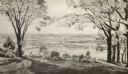
| Description: | View from Brisbois Point. Prairie du Chien lies below, and beyond the Mississippi River rise Iowa's hills. |

| Date: | 1836 |
|---|---|
| Description: | Woodcut of Prairie du Chien in 1836. Text at bottom reads: "Prairie du Chien in 1836. From an old cut." |
If you didn't find the material you searched for, our Library Reference Staff can help.
Call our reference desk at 608-264-6535 or email us at: