 Filter: Categories of Wisconsin Historical Images
Filter: Subject of Mississippi River
Filter: Creator Name of Unknown
Filter: Categories of Wisconsin Historical Images
Filter: Subject of Mississippi River
Filter: Creator Name of Unknown

| Date: | 01 02 1915 |
|---|---|
| Description: | Photographic postcard from the Mississippi of the city of Alma. The city of Alma is along Wisconsin State Highway 35, also known as the Great River Road. T... |

| Date: | 12 29 1914 |
|---|---|
| Description: | Photographic postcard view of Alma looking north. The Mississippi River is in the foreground. Caption reads: "Alma, Wis." |

| Date: | 12 1914 |
|---|---|
| Description: | Photographic postcard view of southern Alma with buildings and bluffs. The Mississippi River and the shoreline are in the foreground. Caption reads: "Alma,... |

| Date: | 08 03 1913 |
|---|---|
| Description: | Colorized postcard of the Mississippi River and bluffs near Alma. A docked paddle boat is near the shoreline. Caption reads: "A Scene from the River, Alma,... |

| Date: | 04 12 1907 |
|---|---|
| Description: | Photographic postcard of an aerial view of town looking North. The Mississippi River is on the left. |

| Date: | |
|---|---|
| Description: | Memohead of the G. Heileman Brewing Company of La Crosse, Wisconsin, manufacturers of keg and bottled beer, with an elevated view of the brewery complex, i... |

| Date: | |
|---|---|
| Description: | Letterhead of the John Gund Brewing Company of La Crosse, Wisconsin, with an elevated view of the brewery complex on the left. On the right is the company ... |

| Date: | 1928 |
|---|---|
| Description: | Map of portions of Wisconsin and Minnesota between Lake Superior and Mississippi River, showing railroads and military road. |

| Date: | 1900 |
|---|---|
| Description: | A map of Wisconsin, eastern Minnesota and Iowa, northern Iowa, and Michigan’s Upper Peninsula, showing railway lines, with those marked with heavy red line... |

| Date: | 1874 |
|---|---|
| Description: | A hand-colored, geological map of Wisconsin show the progress of the state geological survey in 1873 and 1874. Other elements displayed in the map include... |

| Date: | 1835 |
|---|---|
| Description: | Plat for a proposed Sinsinawa City (never built), in Grant County, Wis. When it became clear in the mid-1830s that Wisconsin Territory would be established... |

| Date: | 02 1823 |
|---|---|
| Description: | A map featuring the North American expedition from Pittsburgh to the Rocky Mountains led by Edwin James. |
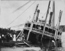
| Date: | 1906 |
|---|---|
| Description: | Group of people stand on pier near the Diamond Jo line steamboat Quincy, sunk in 1906. It was raised and renamed the J.S. There are men on th... |
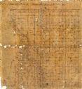
| Date: | |
|---|---|
| Description: | This 19th century manuscript map shows state lands and acreages along the Mississippi River and the sections in parts of what is currently the Town of Shel... |

| Date: | |
|---|---|
| Description: | This 19th century manuscript map shows land claims near the confluence of the Wisconsin River with the Mississippi River in the Town of Bridgeport, Crawfor... |

| Date: | 1887 |
|---|---|
| Description: | Map of the Fox and Wisconsin Rivers to accompany Reuben Gold Thwaites' Historic Waterways. |

| Date: | |
|---|---|
| Description: | Colorized, elevated view of Cassville with the Mississippi River in the background. A church and dwellings are in the foreground. |
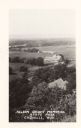
| Date: | |
|---|---|
| Description: | Elevated, photographic postcard view of Nelson Dewey Memorial State Park. There are railroad tracks in the foreground; the Mississippi River is in the back... |
If you didn't find the material you searched for, our Library Reference Staff can help.
Call our reference desk at 608-264-6535 or email us at:

