 Filter: Categories of Wisconsin Historical Images
Filter: Subject of Mississippi River
Filter: Creator Name of Unknown
Filter: Subject of roads
Filter: Categories of Wisconsin Historical Images
Filter: Subject of Mississippi River
Filter: Creator Name of Unknown
Filter: Subject of roads

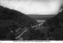
| Date: | 1895 |
|---|---|
| Description: | View down road with the Bay State House on the left. Three houses and a barbershop also line the street. A lamppost is in the left foreground. The Mississ... |

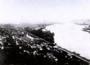
| Date: | 1900 |
|---|---|
| Description: | Elevated view of La Crosse. Caption reads: "Panorama of La Crosse, Wis. from Grand Dad's Bluff." |
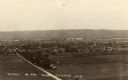
| Date: | 1907 |
|---|---|
| Description: | Elevated view from first peak of Trempealeau, Wisconsin. |
| Date: | 1930 |
|---|---|
| Description: | Elevated view of the north side of town, from high on the bluff. Caption reads: "'Birdseye' No. End Prairie Du Chien, Wis." |
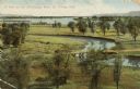
| Date: | 1909 |
|---|---|
| Description: | Elevated view of winding tributaries leading to Mississippi River. A road passes over a bridge in the foreground. Caption reads: "A View on the Mississippi... |
| Date: | |
|---|---|
| Description: | An elevated view of the town of Clayton, Iowa, which is nestled in a valley. The Mississippi River can be seen nearby. Caption reads: "Clayton, Iowa, on th... |

| Date: | 1928 |
|---|---|
| Description: | Map of portions of Wisconsin and Minnesota between Lake Superior and Mississippi River, showing railroads and military road. |

| Date: | 1900 |
|---|---|
| Description: | A map of Wisconsin, eastern Minnesota and Iowa, northern Iowa, and Michigan’s Upper Peninsula, showing railway lines, with those marked with heavy red line... |

| Date: | 1850 |
|---|---|
| Description: | This map of Cassville shows plat of the town, roads, landings and public wharfs and the Mississippi River. |

| Date: | 1776 |
|---|---|
| Description: | Map of the American colonies and land east of the Mississippi River. Prominent cities, forts, Native American land, mountains, rivers and lakes are all sho... |

| Date: | 1782 |
|---|---|
| Description: | Map of America east of the Mississippi River. It shows regions, state boundaries extending to the Mississippi River, cities, forts, Native American lands, ... |

| Date: | 1967 |
|---|---|
| Description: | Aerial view of what is identified by the caption as a "Nuclear power plant near Victory (Vernon Co.), Wis." This would be the La Crosse Boiling Water React... |

| Date: | |
|---|---|
| Description: | Aerial view of the Holiday Inn, between La Crosse on Barron Island in the beautiful Mississippi. A curved road is leading to a bridge across the Mississipp... |
If you didn't find the material you searched for, our Library Reference Staff can help.
Call our reference desk at 608-264-6535 or email us at:
