 Filter: Categories of Wisconsin Historical Images
Filter: Subject of Mississippi River
Filter: Creator Name of Rand McNally
Filter: Subject of transportation
Filter: Categories of Wisconsin Historical Images
Filter: Subject of Mississippi River
Filter: Creator Name of Rand McNally
Filter: Subject of transportation
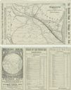
| Date: | 1874 |
|---|---|
| Description: | A folded brochure with a map of the Chicago to Saint Paul rail line through Wisconsin by way of the Chicago & North-Western and West Wisconsin Railways. Th... |

| Date: | 1914 |
|---|---|
| Description: | A business atlas map of Wisconsin, showing the railroads, counties, cities, villages, rivers, lakes, electric lines, and steamship lines in the state. Othe... |

| Date: | 1910 |
|---|---|
| Description: | This map shows railroads, counties, cities and villages, rivers, lakes, and electric lines are shown in Wisconsin, the western portion of Michigan's Upper ... |

| Date: | 1906 |
|---|---|
| Description: | A hand-colored map of Wisconsin identifying the railroads, counties, cities, rivers, and lakes in Wisconsin, eastern Minnesota and Iowa, northern Illinois,... |
If you didn't find the material you searched for, our Library Reference Staff can help.
Call our reference desk at 608-264-6535 or email us at:
