 Filter: Categories of Wisconsin Historical Images
Filter: Subject of Mississippi River
Filter: Type of Map or Atlas
Filter: Subject of transportation
Filter: Categories of Wisconsin Historical Images
Filter: Subject of Mississippi River
Filter: Type of Map or Atlas
Filter: Subject of transportation

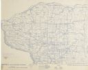
| Date: | 1856 |
|---|---|
| Description: | This map show the surveyed southern part of state and includes "profile of the Milwaukee and Mississippi Rail Road." Counties are shown in pink, green, blu... |

| Date: | 1886 |
|---|---|
| Description: | This map shows U.S. land offices, completed railroads, railroad land grant limits, lakes, rivers, and Indian reservations. Communities, lakes, and rivers a... |

| Date: | 1874 |
|---|---|
| Description: | This map shows lakes, rivers, state, county, and town boundaries, as well as railroads completed, in progress, and contemplated. The map includes a color d... |

| Date: | 1870 |
|---|---|
| Description: | During the War of 1812, the only battle fought in Wisconsin was in Prairie du Chien, in 1814. Made fifty-six years later, this birds eye drawing depicts th... |

| Date: | 1867 |
|---|---|
| Description: | Bird's-eye map of La Crosse with nine insets of residences, schools, and the Court House and Jail. |

| Date: | 1873 |
|---|---|
| Description: | Bird's-eye map of La Crosse from the Mississippi River. |

| Date: | 1880 |
|---|---|
| Description: | Bird's-eye map over the Mississippi River of Fountain City. Paddle steamers and steamboats are on the river, and bluffs are in the background. |

| Date: | 1882 |
|---|---|
| Description: | This basic reference map of the state shows natural features, railroads, county seats, and political boundaries against the G.L.O. township and range grid.... |

| Date: | 1910 |
|---|---|
| Description: | Wisconsin Geological and Natural History Survey, by Lawrence Martin reproduced from a model of the state prepared by W.O. Hotchkiss and F.T. Thwaites and m... |

| Date: | 1868 |
|---|---|
| Description: | Showing the counties, towns and railroads. Partly colored. Scale: 1 inch = 20 miles. |

| Date: | 1898 |
|---|---|
| Description: | Shows railway lines in Wisconsin marked in red and counties in colors. The meridians are Greenwich, Wisconsin and Washington, Wisconsin. The map folds into... |

| Date: | |
|---|---|
| Description: | Plan of township no. 3 north, range no. 5 west of the 4th principal meridian. |

| Date: | 1854 |
|---|---|
| Description: | Map reads, "Map of Wisconsin". The map includes the counties, an inset of the city of Milwaukee, total population of each county and of the state. The scal... |

| Date: | |
|---|---|
| Description: | Map reads: "Historic and Scenic Wisconsin — Land of Gathering Waters." In an inset there is a hand-painted depiction of the Wisconsin State Seal. For some ... |

| Date: | 1937 |
|---|---|
| Description: | Official state highway map, with insets of cities. |

| Date: | 1932 |
|---|---|
| Description: | This map includes a distance table, text, and insets maps of, Superior, Ashland, Marinette, Green Bay, Appleton, Manitowoc, Oshkosh, Fond Du Lac, Janesvill... |
| Date: | 1896 |
|---|---|
| Description: | Section 4 of 12, this bicycle road map features Wisconsin bicycle routes in the counties of Iowa, Grant, and La Fayette. |

| Date: | 1896 |
|---|---|
| Description: | Section 5 of 12, this bicycle road map features Wisconsin bicycle routes in the counties of La Crosse, Monroe, Vernon, Crawford, Richland, Sauk, Juneau, an... |
If you didn't find the material you searched for, our Library Reference Staff can help.
Call our reference desk at 608-264-6535 or email us at:

