 Filter: Categories of Wisconsin Historical Images
Filter: Subject of Mines and mineral resources
Filter: Year of 1900-1999
Filter: Categories of Wisconsin Historical Images
Filter: Subject of Mines and mineral resources
Filter: Year of 1900-1999

| Date: | 1923 |
|---|---|
| Description: | This map shows the movement of iron ore in areas of Ohio, Pennsylvania, New York, New Jersey, Lake Erie, Lake Ontario, and parts of Ontario, Maryland, and ... |

| Date: | 1923 |
|---|---|
| Description: | This map shows the movement of iron ore in parts of Minnesota, Wisconsin, and the Upper Peninsula of Michigan, and includes parts of Lake Superior, Green B... |

| Date: | 1923 |
|---|---|
| Description: | This map shows the movement of iron ore along the Great Lakes. Portions of Minnesota, Iowa, Wisconsin, Illinois, Indiana, Ohio, Michigan, New York, Vermont... |
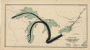
| Date: | 1923 |
|---|---|
| Description: | This map shows the movement of anthracite coal throughout Minnesota, Wisconsin, Ontario, Quebec, Michigan, Illinois, Indiana, and New York. Iowa, Vermont,... |

| Date: | 1956 |
|---|---|
| Description: | International VF-192 tandem dump truck with load of coal. Powered by V8-478 CID gas engine. Painted on the driver's side door: "Black Nugget Coal Mining Co... |

| Date: | 1907 |
|---|---|
| Description: | Cover of the book The Pinkerton Labor Spy by Morris Friedman. The book was a work of non-fiction detailing the use of spies during labor disputes b... |

| Date: | 12 1903 |
|---|---|
| Description: | This manuscript blueprint map shows streets and lots and includes certifications in the left margin. Horizontal streets top to bottom are: Iroquois, Main, ... |

| Date: | 1937 |
|---|---|
| Description: | Pictorial map showing historical events and locations within the state of Wisconsin, as well as waterways and counties. Original caption on the bottom marg... |

| Date: | 1985 |
|---|---|
| Description: | This map shows mining, White River, Silver Creek, Bad River, Agogic Lake, Chequamegon Bay, smaller lakes, the Bad River Indian Reservation, and communities... |

| Date: | 1903 |
|---|---|
| Description: | This blue line print shows quartzite areas, mines, railroads, and roads. The map covers townships 11-13 north, ranges 4-8 east, in parts of Sauk and Columb... |

| Date: | 1904 |
|---|---|
| Description: | This blue line print map includes 4 cross sections with relief shown by contours and spot heights. The topography was taken from the United States Geologic... |
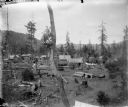
| Date: | 1903 |
|---|---|
| Description: | Elevated view of a mining camp in the western United States. At this time Carl Peterson was writing letters home to Christine Jenson about his journey. |
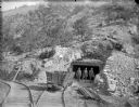
| Date: | 1903 |
|---|---|
| Description: | View down set of two railroad tracks towards four coal miners posing in front of a mine entrance near a coal car. The caption in the book reads, "Strike-br... |

| Date: | 1922 |
|---|---|
| Description: | Elevated view from hill looking down on a mining town surrounded by wooded hills. There are wooden sidewalks between the houses. In the background on the l... |
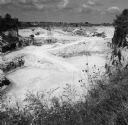
| Date: | 1993 |
|---|---|
| Description: | Elevated view of trucks and conveyor belts working in the background of a limestone quarry. Grass and plants with small blossoms are in the foreground at t... |

| Date: | 1903 |
|---|---|
| Description: | Caption on negative sleeve reads, "Mining (?) town with view of saloon, restaurant and general store." A boardwalk runs along the fronts of the buildings. ... |

| Date: | 1910 |
|---|---|
| Description: | View across water towards the Lyle Mine and Ranier on the shoreline of Rainy Lake. |

| Date: | 1910 |
|---|---|
| Description: | A view across water towards the Rainy Lake shoreline, which includes Lyle Mine and Ranier. |
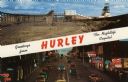
| Date: | 1959 |
|---|---|
| Description: | Two views of Hurley. At the top is the Cary Mine. On the bottom is Silver Street lined with clubs and electric signs. Caption reads: "Greetings from Hurley... |

| Date: | 07 25 1927 |
|---|---|
| Description: | Men driving tractors pulling trailers, which are being loaded from a hopper at a granite quarry or mine. On the far right is a steam shovel. |
If you didn't find the material you searched for, our Library Reference Staff can help.
Call our reference desk at 608-264-6535 or email us at: