 Filter: Categories of Wisconsin Historical Images
Filter: Subject of Mines and mineral resources
Filter: Subject of water
Filter: Categories of Wisconsin Historical Images
Filter: Subject of Mines and mineral resources
Filter: Subject of water

| Date: | 05 10 1919 |
|---|---|
| Description: | Workers digging in a muddy trench near bridge no. 1, mine no. 2. Benham was a "company town" created by International Harvester for the workers of the Wisc... |
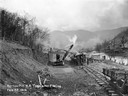
| Date: | 02 22 1919 |
|---|---|
| Description: | Workers using a steam shovel to dig a "borrow pit" for the no. 2 mine. The shovel is loading soil onto a rail car on a narrow gauge railroad track. Benham ... |
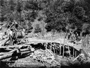
| Date: | 05 03 1919 |
|---|---|
| Description: | Workers building a culvert over Maggard's Branch near mine no. 2. Benham was a "company town" created by International Harvester for the workers employed i... |
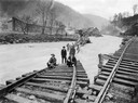
| Date: | 1919 |
|---|---|
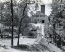
| Description: | Men standing on the exposed portion of a flooded railroad track as a swiftly moving torrent of water is rushing past. Benham was a "company town" created b... |
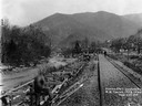
| Date: | 03 29 1919 |
|---|---|
| Description: | Men building a dock along railroad tracks. The tracks run along a stream or small river. Benham was a "company town" created by International Harvester for... |

| Date: | 1885 |
|---|---|
| Description: | Ore dock of the Milwaukee, Lake Shore, and Western Railroad, with a pile of logs in the foreground and docked ships in the background. |

| Date: | 1885 |
|---|---|
| Description: | View of the ore dock of the Milwaukee, Lake Shore, and Western Railroad. Large logs, buildings and a railroad bridge are in the foreground. |

| Date: | 1929 |
|---|---|
| Description: | View of an ore dock on Chequamegon Bay. Buildings on the shore of the bay can be seen, however, not the water. |

| Date: | 1920 |
|---|---|
| Description: | Caption reads: "Mammoth Ore Docks, Ashland, Wis." A building and roads are in the foreground. Several ore ships can be seen. |
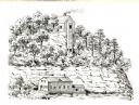
| Date: | 1836 |
|---|---|
| Description: | The shot tower at Tower Hill State Park. |
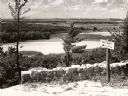
| Date: | 1950 |
|---|---|
| Description: | A view from a bluff on Tower HIll overlooking the Wisconsin River. A sign on the right reads: "Shot Shaft". |
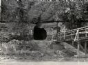
| Date: | 1950 |
|---|---|
| Description: | View across river towards the tunnel leading to the bottom of the shot tower shaft at Tower Hill State Park. There is a rustic bridge on the right leading ... |
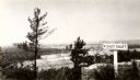
| Date: | 1945 |
|---|---|
| Description: | View from the bluff at Tower Hill State Park of the Wisconsin River. A sign on the right reads: "Tower Hill State Park Shot Shaft". |

| Date: | 1849 |
|---|---|
| Description: | Geological map of the mineral region around Lake Superior, including portions of Michigan, Wisconsin, Iowa and Illinois. |

| Date: | |
|---|---|
| Description: | Mine, Mill & Smelters Union reading by a lake at Highlander Folk School. Will Thomas, second on the right, smoking a pipe. |

| Date: | 1939 |
|---|---|
| Description: | International PA-100 power unit operating a Pomona water pump in a lead and zinc mine. A box labeled "dynamite" is in the foreground. |
| Date: | 08 1938 |
|---|---|
| Description: | Mine building at a gold and mica mine operated by the Mineral Mining Corporation. A body of water is in the foreground on the left side of a partially cons... |
| Date: | 1920 |
|---|---|
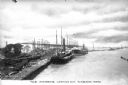
| Description: | A view of boats laden with ore docked at the harbor. Caption reads: "The Harbor -- Looking Out, Lorain, Ohio." |
If you didn't find the material you searched for, our Library Reference Staff can help.
Call our reference desk at 608-264-6535 or email us at:

