 Filter: Categories of Wisconsin Historical Images
Filter: Subject of Mines and mineral resources
Filter: Subject of streets
Filter: Categories of Wisconsin Historical Images
Filter: Subject of Mines and mineral resources
Filter: Subject of streets
| Date: | |
|---|---|
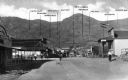
| Description: | View down Tennessee Avenue, with the locations of mines marked in the hills in the distance. Men walk past shops on either side of the avenue. |

| Date: | 11 1905 |
|---|---|
| Description: | Sanborn map of Hurley including mining features. |

| Date: | 12 1903 |
|---|---|
| Description: | This manuscript blueprint map shows streets and lots and includes certifications in the left margin. Horizontal streets top to bottom are: Iroquois, Main, ... |
| Date: | 1959 |
|---|---|
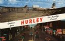
| Description: | Two views of Hurley. At the top is the Cary Mine. On the bottom is Silver Street lined with clubs and electric signs. Caption reads: "Greetings from Hurley... |

| Date: | 1838 |
|---|---|
| Description: | Drawing of Shullsburg. There is a numbered key on the left that reads, at top: "Explanation. Nos. Denote present Site." Streets are named on the map and ma... |
If you didn't find the material you searched for, our Library Reference Staff can help.
Call our reference desk at 608-264-6535 or email us at: