 Filter: Categories of Wisconsin Historical Images
Filter: Subject of Mines and mineral resources
Filter: Subject of service industries
Filter: Categories of Wisconsin Historical Images
Filter: Subject of Mines and mineral resources
Filter: Subject of service industries
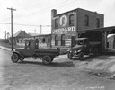
| Date: | 06 18 1925 |
|---|---|
| Description: | Two International delivery trucks leaving premises of the Goddard Fuel Company. The company's building and trucks carry advertising for "Hanna Coal" which... |
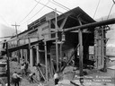
| Date: | 05 05 1919 |
|---|---|
| Description: | Workers preparing the power house for the addition of a 1250 k.w. turbo generator. A man in the foreground is taking a drink of water from a pail. Benham w... |
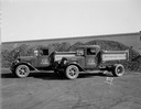
| Date: | 09 19 1933 |
|---|---|
| Description: | Two new West Kentucky Coal Co. 1.5 ton International trucks in front of piles of Wesco Royal Red Ash coal at the coal yards at 1433 Monroe Street. |
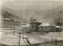
| Date: | 1919 |
|---|---|
| Description: | YMCA building, with Benham Hotel and mountains in thevbackground. Benham was an International Harvester "company town." |
| Date: | 08 1938 |
|---|---|
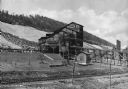
| Description: | Mine building at a gold and mica mine operated by the Mineral Mining Corporation. A body of water is in the foreground on the left side of a partially cons... |
| Date: | |
|---|---|
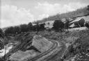
| Description: | Elevated view of the P & R coal storage yard, with railroad tracks winding around a curve at the foot of a small hill. The coal yard and buildings are at t... |
| Date: | |
|---|---|
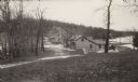
| Description: | View of the P & R coal storage yard, including railroad tracks and coal storage building. Hills are in the background. |
| Date: | 02 1925 |
|---|---|
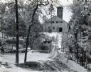
| Description: | Workers' houses stand in front of the Fayette Tourists Lodge. After the Jackson Iron Company left in 1891, Fayette became a tourist destination and is now ... |

| Date: | 1899 |
|---|---|
| Description: | This 1899 map of Douglas County, Wisconsin, shows the township and range grid, towns, sections, cities, villages and railroad stations, mines, roads, railr... |

| Date: | 1864 |
|---|---|
| Description: | This map is pen and watercolor on paper and shows profile and geological formation of Blue Mound and location of Arnold’s Hotel and Brigham Lead Mines. |

| Date: | 1870 |
|---|---|
| Description: | This map is ink and color on tracing cloth and shows Iron Ridge, the hotel and saw mill at Iron Ridge Village, Milwaukee & St. Paul Railway, plank road, an... |
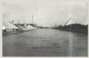
| Date: | 12 16 1957 |
|---|---|
| Description: | View across water, with cranes among piles of coal along the right, and among piles of other materials on the left. Smoke is in the distance on the right, ... |

| Date: | |
|---|---|
| Description: | Letterhead of the Pennsylvania Coal & Supply Company, with the company trademark: the initials "P" and "C" printed in red ink, and a head and shoulders ima... |

| Date: | 1864 |
|---|---|
| Description: | This map is pen and watercolor on paper and shows a profile and the geological formation of Blue Mound. Also shown is the location of Arnold's Hotel and Br... |

| Date: | 1903 |
|---|---|
| Description: | Caption on negative sleeve reads, "Mining (?) town with view of saloon, restaurant and general store." A boardwalk runs along the fronts of the buildings. ... |
If you didn't find the material you searched for, our Library Reference Staff can help.
Call our reference desk at 608-264-6535 or email us at: