 Filter: Categories of Wisconsin Historical Images
Filter: Subject of Mines and mineral resources
Filter: Subject of harbors
Filter: Categories of Wisconsin Historical Images
Filter: Subject of Mines and mineral resources
Filter: Subject of harbors
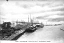
| Date: | 1920 |
|---|---|
| Description: | A view of boats laden with ore docked at the harbor. Caption reads: "The Harbor -- Looking Out, Lorain, Ohio." |
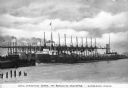
| Date: | |
|---|---|
| Description: | A view of ships laden with ore unloading at Brown Hoists. Caption reads: "Unloading Ore at Brown Hoists, Lorain, Ohio." |
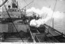
| Date: | 1915 |
|---|---|
| Description: | Elevated view of an iron ore ship unloading. Several workers are on board the ship. Caption reads: "Unloading Iron Ore At Sparrows Point, MD." |
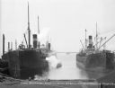
| Date: | 1915 |
|---|---|
| Description: | View of several ships at the ore docks of Maryland Steel Company. Text on the ship on the left may read "Craigeab" (text is difficult to make out). The nam... |
| Date: | 02 11 1925 |
|---|---|
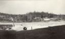
| Description: | View of the large abandoned furnace complex, left, company store, far right, and blacksmith shop behind the company store, on the site of the Jackson Iron ... |
| Date: | 02 1925 |
|---|---|
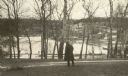
| Description: | An unidentified man looks across Snail Shell Harbor at the remains of the Jackson Iron Company works. The large furnace complex is visible through the tree... |
| Date: | 02 1925 |
|---|---|
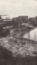
| Description: | Elevated view of the abandoned Jackson Iron Company furnace complex at Fayette, on the shore of Snail Shell Harbor. Lake Michigan is in the background. |
| Date: | 02 1925 |
|---|---|
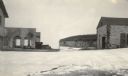
| Description: | Dolomite cliffs along Snail Shell Harbor are seen in the background between the ruined buildings of the company store, left, and the machine shop on the gr... |
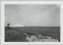
| Date: | |
|---|---|
| Description: | View from shoreline of dock site towards Lake Superior, showing sulphur pile and a large chute in the background. |
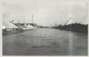
| Date: | 12 16 1957 |
|---|---|
| Description: | View across water, with cranes among piles of coal along the right, and among piles of other materials on the left. Smoke is in the distance on the right, ... |

| Date: | 1923 |
|---|---|
| Description: | This map shows major cities surrounding the Great Lakes. Portions of Minnesota, Iowa, Illinois, Indiana, Ohio, Michigan, New York, Vermont, Massachusetts,C... |

| Date: | 1719 |
|---|---|
| Description: | Map of the British colonies and territories in North American, depicting cities, Native American land, rivers, mines, forts, trees, and topography east of ... |
If you didn't find the material you searched for, our Library Reference Staff can help.
Call our reference desk at 608-264-6535 or email us at: