Filter: Categories of Wisconsin Historical Images
Filter: Subject of Mines and mineral resources
Filter: County of Sauk
Filter: Categories of Wisconsin Historical Images
Filter: Subject of Mines and mineral resources
Filter: County of Sauk
| Date: | 1909 |
|---|---|
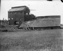
| Description: | A deteriorating mining building seen from across a field. |
| Date: | 1836 |
|---|---|
| Description: | The shot tower at Tower Hill State Park. |
| Date: | 1945 |
|---|---|
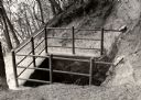
| Description: | The top of the shot tower shaft with the entrance. The sign on the railing reads: "Do Not Throw Anything Down This Shaft". |
| Date: | 1945 |
|---|---|
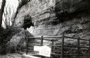
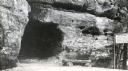
| Description: | The tunnel at the bottom of the shot tower shaft. |
| Date: | 1950 |
|---|---|
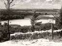
| Description: | A view from a bluff on Tower HIll overlooking the Wisconsin River. A sign on the right reads: "Shot Shaft". |
| Date: | 1950 |
|---|---|
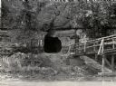
| Description: | View across river towards the tunnel leading to the bottom of the shot tower shaft at Tower Hill State Park. There is a rustic bridge on the right leading ... |
| Date: | 1945 |
|---|---|
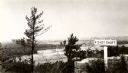
| Description: | View from the bluff at Tower Hill State Park of the Wisconsin River. A sign on the right reads: "Tower Hill State Park Shot Shaft". |
| Date: | 1945 |
|---|---|
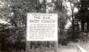
| Description: | A marker at the former site of the smelter which stood at the top of the shot tower shaft. The sign reads: "Tower Hill State Park The Old Shot Tower At thi... |
| Date: | 1945 |
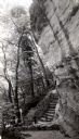
|---|---|
| Description: | Tower Hill State Park trail leading to the top of the shot tower shaft. |
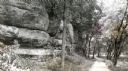
| Date: | 1945 |
|---|---|
| Description: | Tower Hill State Park trail to the top of the shot tower shaft. |
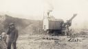
| Date: | 10 19 1925 |
|---|---|
| Description: | A workman smokes a cigarette in the foreground as a steam shovel loads iron ore at the Cahoon Mine. |

| Date: | 07 1870 |
|---|---|
| Description: | This map of Ironton is pen-and-ink on paper and shows lots and block numbers, mill, foundry buildings, limestone quarry, iron mine, and roads. Relief is sh... |

| Date: | 12 1903 |
|---|---|
| Description: | This manuscript blueprint map shows streets and lots and includes certifications in the left margin. Horizontal streets top to bottom are: Iroquois, Main, ... |

| Date: | 1903 |
|---|---|
| Description: | This blue line print shows quartzite areas, mines, railroads, and roads. The map covers townships 11-13 north, ranges 4-8 east, in parts of Sauk and Columb... |

| Date: | 1904 |
|---|---|
| Description: | This blue line print map includes 4 cross sections with relief shown by contours and spot heights. The topography was taken from the United States Geologic... |
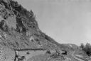
| Date: | 07 1936 |
|---|---|
| Description: | A worker is pulling a wheelbarrow behind him while walking alongside a narrow gauge railroad track at the south end of the East Bluff near Devil's Lake. Em... |
If you didn't find the material you searched for, our Library Reference Staff can help.
Call our reference desk at 608-264-6535 or email us at: