 Filter: Categories of Wisconsin Historical Images
Filter: Subject of Mines and mineral resources
Filter: County of Iowa
Filter: Subject of transportation
Filter: Categories of Wisconsin Historical Images
Filter: Subject of Mines and mineral resources
Filter: County of Iowa
Filter: Subject of transportation
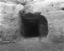
| Date: | 1920 |
|---|---|
| Description: | Entrance of the tunnel to the bottom of the shot tower. There is graffiti around the entrance. |
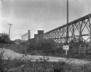
| Date: | 1930 |
|---|---|
| Description: | View from off the road of a mine near Linden. A road sign alerts drivers that the State Truck Highway 39 is one mine away. |
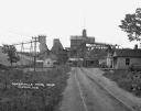
| Date: | 1925 |
|---|---|
| Description: | View down road leading up to the Cokerville Mine. Two horses pulling a wagon are near the road, and automobiles are parked on the right near a building wit... |

| Date: | 1836 |
|---|---|
| Description: | This early to mid-19th century map shows the township and range system, sections, landownership, furnaces, lead mines, copper mines, and roads in the vicin... |
If you didn't find the material you searched for, our Library Reference Staff can help.
Call our reference desk at 608-264-6535 or email us at: