 Filter: Categories of Wisconsin Historical Images
Filter: Subject of Mines and mineral resources
Filter: Community of Baraboo
Filter: Categories of Wisconsin Historical Images
Filter: Subject of Mines and mineral resources
Filter: Community of Baraboo
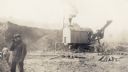
| Date: | 10 19 1925 |
|---|---|
| Description: | A workman smokes a cigarette in the foreground as a steam shovel loads iron ore at the Cahoon Mine. |

| Date: | 1903 |
|---|---|
| Description: | This blue line print shows quartzite areas, mines, railroads, and roads. The map covers townships 11-13 north, ranges 4-8 east, in parts of Sauk and Columb... |

| Date: | 1904 |
|---|---|
| Description: | This blue line print map includes 4 cross sections with relief shown by contours and spot heights. The topography was taken from the United States Geologic... |
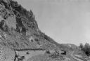
| Date: | 07 1936 |
|---|---|
| Description: | A worker is pulling a wheelbarrow behind him while walking alongside a narrow gauge railroad track at the south end of the East Bluff near Devil's Lake. Em... |
If you didn't find the material you searched for, our Library Reference Staff can help.
Call our reference desk at 608-264-6535 or email us at: