 Filter: Categories of Wisconsin Historical Images
Filter: Subject of Military camps
Filter: Year of 1900-1999
Filter: Year of 1900-1909
Filter: Categories of Wisconsin Historical Images
Filter: Subject of Military camps
Filter: Year of 1900-1999
Filter: Year of 1900-1909
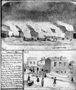
| Date: | 11 08 1906 |
|---|---|
| Description: | Two Civil War watercolor drawings by John Gaddis, Company E, 12th Wisconsin Volunteer Infantry, showing the regiment in bivouac, and later their headquarte... |

| Date: | 1909 |
|---|---|
| Description: | This is one of a set of two topographical maps showing land use, roads, railroads, bridges, and buildings with ownership in parts of LaFayette, Greenfield,... |

| Date: | 1900 |
|---|---|
| Description: | This map shows portion of the military road from Fond du Lac to the Wisconsin River near Fort Winnebago, with mile markers and adjacent land use. A few pro... |

| Date: | 1909 |
|---|---|
| Description: | This the second of a set of two topographical maps showing land use, roads, railroads, bridges, and buildings with ownership in parts of LaFayette, Greenfi... |
If you didn't find the material you searched for, our Library Reference Staff can help.
Call our reference desk at 608-264-6535 or email us at: