 Filter: Categories of Wisconsin Historical Images
Filter: Subject of Military bases
Filter: Year of 1800-1899
Filter: Categories of Wisconsin Historical Images
Filter: Subject of Military bases
Filter: Year of 1800-1899

| Date: | 1800 |
|---|---|
| Description: | Map of the new state of Tennessee. It shows borders, numerous boundary lines (particularly Native American boundaries), towns (European and Native American... |

| Date: | 1851 |
|---|---|
| Description: | Elevated view across water towards Fort Howard. In the foreground is a man standing on a pier, and in the water nearby are five men rowing in a boat. Capti... |
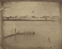
| Date: | 1851 |
|---|---|
| Description: | A rare photograph of U.S. Army soldiers stationed at Fort Howard rowing a boat on the Fox River. Fort Howard, built in 1816, was the first in the chain of ... |
If you didn't find the material you searched for, our Library Reference Staff can help.
Call our reference desk at 608-264-6535 or email us at: