 Filter: Categories of Wisconsin Historical Images
Filter: Subject of Military bases
Filter: Subject of housing
Filter: Categories of Wisconsin Historical Images
Filter: Subject of Military bases
Filter: Subject of housing
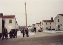
| Date: | 1990 |
|---|---|
| Description: | Fort McCoy, showing housing, and soldiers standing at the back of a truck at wintertime. |

| Date: | 1793 |
|---|---|
| Description: | Detailed topographical map of the Ohio River between Clarkville and Louisville. It shows plots of farmland, forest, islands, garden plots, houses, Fort Fe... |
If you didn't find the material you searched for, our Library Reference Staff can help.
Call our reference desk at 608-264-6535 or email us at: