 Filter: Categories of Wisconsin Historical Images
Filter: Subject of Michigan, Lake
Filter: Year of 1900-1999
Filter: Categories of Wisconsin Historical Images
Filter: Subject of Michigan, Lake
Filter: Year of 1900-1999

| Date: | 1930 |
|---|---|
| Description: | Aerial view, looking northeast, across Mud Lake with North Bay in the background, showing cultivated fields and wooded land. |

| Date: | 1930 |
|---|---|
| Description: | Aerial view looking north across the wooded peninsula separating Europe Bay (top) from Newport Bay. This area is now part of Newport State Park. |

| Date: | 1930 |
|---|---|
| Description: | Aerial view of the northern tip of the Door Peninsula, looking north. Europe Lake is in the center, with Europe Bay to the right. Plum Island and Washingto... |

| Date: | 1930 |
|---|---|
| Description: | Aerial view looking northeast, with Rowley's Bay in the foreground. Europe Lake is to the left, with Europe Bay and Newport Bay separated by a narrow peni... |

| Date: | 1930 |
|---|---|
| Description: | Aerial view over northern Door County, looking northeast across Europe Lake and Europe Bay toward Plum and Washington Islands. Farm fields and orchards con... |

| Date: | 1930 |
|---|---|
| Description: | Aerial view from over Moonlight Bay, looking east across Bues Point to Spike Horn Bay and Cana Island. The Cana Island Lighthouse is seen as a ship passes ... |

| Date: | 1930 |
|---|---|
| Description: | Aerial view, looking north, across the beach and pier on Europe Bay to Europe Lake and beyond to Washington Island. The land south (to the right) of Europe... |
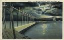
| Date: | 1927 |
|---|---|
| Description: | Hand-colored postcard view of a pier and lighthouse at night. The moon shines through clouds, and light shines in two directions from the beacon on top of ... |

| Date: | 1906 |
|---|---|
| Description: | Hand-colored postcard view of the Sturgeon Bay ship canal from the bay toward shore. A sailboat is on the left and a lighthouse is on shore on the right. C... |
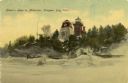
| Date: | 1908 |
|---|---|
| Description: | Hand-colored postcard view of Lover's Leap in Sturgeon Bay during winter. The view is from the frozen lake looking toward a lighthouse on shore. Caption re... |
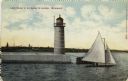
| Date: | 1910 |
|---|---|
| Description: | Hand-colored postcard view of a pier and lighthouse at the entrance to Milwaukee's harbor. Two people sail in a small boat to the right of the lighthouse, ... |

| Date: | 1941 |
|---|---|
| Description: | This 1941 tourist map of Washington Island, Wisconsin, shows points of interest and places of business. Some information is shown pictorially. Rock, Hog, D... |
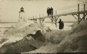
| Date: | 1910 |
|---|---|
| Description: | Postcard view of three men on an elevated walk on an icy pier near the shoreline. A women and young boy stand on the pier below the walk. There is a lighth... |
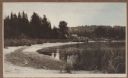
| Date: | 1915 |
|---|---|
| Description: | Elevated view of Fish Creek Harbor as a boat approaches the pier and warehouse. In the foreground are houses with outbuildings, gardens and a small orchard... |
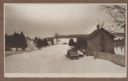
| Date: | 1915 |
|---|---|
| Description: | Winter scene from Egg Harbor Road (Highway 42) in Fish Creek looking north toward frozen Fish Creek Harbor with the bluffs in Peninsula State Park beyond. ... |
| Date: | 1915 |
|---|---|
| Description: | A rustic foot bridge over Fish Creek connects Peninsula State Park (foreground) with the village of Fish Creek. The Vits house is at the right end of the b... |

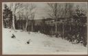
| Date: | 1915 |
|---|---|
| Description: | Elevated view, looking north, from the Hotz family compound near the bluff entrance to Fish Creek. Evergreens and bare birch trees stand in the foreground,... |
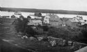
| Date: | 1915 |
|---|---|
| Description: | View looking north over Fish Creek Bay, with Hen Island and Peninsula State Park in the background. There is snow on the ground, and evergreens and bare bi... |
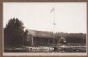
| Date: | 1912 |
|---|---|
| Description: | View from water of simple frame structure with rustic porch rail standing on the Fish Creek beach. A pier extends from the porch and a flag flies on a tall... |
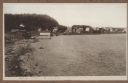
| Date: | 1912 |
|---|---|
| Description: | View looking west from the Hotz property on Fish Creek Beach. The Thorp bathhouse is on the left, with the Welcker bathhouses beyond. There are houses an... |
If you didn't find the material you searched for, our Library Reference Staff can help.
Call our reference desk at 608-264-6535 or email us at: