 Filter: Categories of Wisconsin Historical Images
Filter: Subject of Michigan, Lake
Filter: Year of 1900-1999
Filter: Categories of Wisconsin Historical Images
Filter: Subject of Michigan, Lake
Filter: Year of 1900-1999
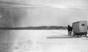
| Date: | 02 1924 |
|---|---|
| Description: | A single horse pulls an enclosed sleigh across a frozen Door County harbor. Houses and a church are visible onshore. |
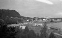
| Date: | 1925 |
|---|---|
| Description: | Elevated view of Fish Creek from the east; the bluff rises on the left, the harbor is on the right. The cottage in the foreground with pergola and lattice ... |
| Date: | 1925 |
|---|---|
| Description: | View looking north on the shore of Europe bay. A picturesque old pine stands near the site of the old pier. |
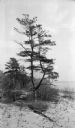
| Date: | 1925 |
|---|---|
| Description: | Rocky shoreline at Nelson Point, now in Peninsula State Park. |

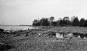
| Date: | 1914 |
|---|---|
| Description: | A business atlas map of Wisconsin, showing the railroads, counties, cities, villages, rivers, lakes, electric lines, and steamship lines in the state. Othe... |

| Date: | 1915 |
|---|---|
| Description: | A map showing the location of post offices in Wisconsin and Michigan that were in operation as of April, 1915, along with the mail routes in use as well as... |

| Date: | 1917 |
|---|---|
| Description: | A geological survey map that shows the sedimentary and igneous deposits in southeastern Wisconsin and south central Wisconsin, as well as the limits of gla... |

| Date: | 1917 |
|---|---|
| Description: | A geological survey map of southeastern Wisconsin that shows the configuration of the bedrock beneath the glacial drift and other deposits in southeastern ... |

| Date: | 1917 |
|---|---|
| Description: | A geological survey map that map of southeastern Wisconsin shows the surface deposits east of the Wisconsin River, from the Illinois state line north to Ne... |

| Date: | 1923 |
|---|---|
| Description: | This early road map shows the system of roads in Wisconsin, northern Illinois, northeastern Iowa, southeastern Minnesota, and the western portion of Michig... |

| Date: | 1931 |
|---|---|
| Description: | This U.S. Geological Survey map of Wisconsin shows counties, cities and villages, lighthouses, Indian reservations, military reservations, and bird and gam... |
| Date: | 1923 |
|---|---|
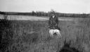
| Description: | A well-dressed man poses holding a German short-haired pointer on a leash near the outlet of the Fish Creek into the harbor. |

| Date: | 1923 |
|---|---|
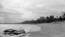
| Description: | A small cottage is barely visible through the trees on the rocky shore at Nelson Point, now part of Peninsula State Park. |
| Date: | 1923 |
|---|---|
| Description: | Sunlight glints off the water under a threatening sky. |
| Date: | 1913 |
|---|---|
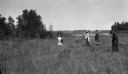
| Description: | A couple, center, and two girls pose in an opening on high ground. The girl on the left is the photographer's daughter, Margaret. The man carries two picn... |
| Date: | 1920 |
|---|---|
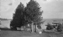
| Description: | View from lawn of small boats which have been pulled onto the shore alongside a pier at North Bay. White cedars (arbor vitae) grow along the pier and on sh... |
| Date: | 1922 |
|---|---|
| Description: | White capped waves break near the Door County shore. |

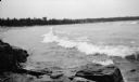
| Date: | 1933 |
|---|---|
| Description: | This road map shows state and county roads in Wisconsin, northern Illinois, northeastern Iowa, eastern Minnesota, and the western portion of Michigan's Upp... |

| Date: | 1933 |
|---|---|
| Description: | This map of Wisconsin and eastern Minnesota identifies federal and state highways in the area. Railroads are shown with the mileage between stops indicated... |

| Date: | 1935 |
|---|---|
| Description: | This three-part map from the U.S. Bureau of Public Roads identifies highways in Wisconsin that have been improved, indicating those which are federal highw... |
If you didn't find the material you searched for, our Library Reference Staff can help.
Call our reference desk at 608-264-6535 or email us at: