Filter: Categories of Wisconsin Historical Images
Filter: Subject of Michigan, Lake
Filter: Year of 1900-1999
Filter: Year of 1960-1969
Filter: Subject of human settlements
Filter: Categories of Wisconsin Historical Images
Filter: Subject of Michigan, Lake
Filter: Year of 1900-1999
Filter: Year of 1960-1969
Filter: Subject of human settlements
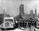
| Date: | 1962 |
|---|---|
| Description: | Sailors passing cases of bottled Coca-Cola (soda) from an International truck to a ship docked at Chicago. City skyline in background. |
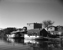
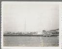
| Date: | 05 05 1963 |
|---|---|
| Description: | View across water towards two fishing boats moored at a dock. |
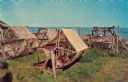
| Date: | 1967 |
|---|---|
| Description: | Fishing nets drying along the shore of Lake Michigan. |
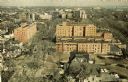
| Date: | 1964 |
|---|---|
| Description: | Elevated view of the city looking north along the shore of Lake Michigan. |

| Date: | 1969 |
|---|---|
| Description: | This Post Office Department map identifies post offices, summer post offices, rural stations, highway post offices, Post Office sectional centers, rural de... |

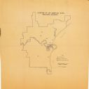
| Date: | 1966 |
|---|---|
| Description: | This map from the 1960s provides a detailed street map of Milwaukee County and eastern Waukesha County as far west as Menomonee Falls and Muskego Lake. A p... |

| Date: | 1968 |
|---|---|
| Description: | A tourist map of Milwaukee County and of downtown Milwaukee. The Map of Milwaukee County identifies the location of some of the points of interests in the ... |

| Date: | 1965 |
|---|---|
| Description: | A map of Milwaukee County showing the county supervisor districts and the city wards. The map also includes the names of those on the on the board of elect... |

| Date: | 1960 |
|---|---|
| Description: | Color coded map in pink, yellow, blue, and brown of Milwaukee County State and County trunk highways. The map includes a legend of symbols: "STEAM RAIL ROA... |
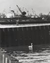
| Date: | 1964 |
|---|---|
| Description: | Docks at Jones Island with a lone swan swimming. Many large ships and city buildings can be seen in the background. |
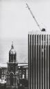
| Date: | 1967 |
|---|---|
| Description: | Elevated view of a detail on the Marshall & Ilsley Bank building, under construction. There is a crane on the roof. On the left is the tower of St. John's ... |

| Date: | 1961 |
|---|---|
| Description: | This map shows streets and some points of interest. Kewaunee River and Lake Michigan are both labeled. |

| Date: | 1961 |
|---|---|
| Description: | This is a photocopy of a map in blue line print that shows streets and places of interest. Inscribed in pen, at the bottom of the map, reads: "Sen. Zaborsk... |

| Date: | 1966 |
|---|---|
| Description: | A colored map depiction of Door County, Wisconsin, with pictorial highlights, titled: "Door County — Wisconsin's Air Conditioned Peninsula Playground." |

| Date: | 07 25 1967 |
|---|---|
| Description: | Newspaper caption reads: "Passersby don't know it, but what appears to be a coonskin cap around the neck of Todd Vasas, 16, of 2773 S. Shore Drive, is the ... |
| Date: | 07 25 1960 |
|---|---|
| Description: | Ephraim pier in Eagle Harbor. The pier is made of timbers. A dock and boathouse are on the right. Bare masts rise above the boats. The shoreline and trees ... |
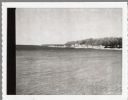
| Date: | 04 17 1963 |
|---|---|
| Description: | Egg Harbor pier. The shoreline and trees are on the right. There is a cottage area along the shoreline along with a small beach. |
| Date: | 08 1964 |
|---|---|
| Description: | This map shows the city limits, Lake Michigan, the Manitowoc River, Silver Creek, designated sample sites with manuscript annotations, central business dis... |

| Date: | 06 14 1961 |
|---|---|
| Description: | Aerial view of North and South Harbor Tracts, looking north from South Pier No. 2. There are skyscrapers in the background. there are multiple items of mac... |
If you didn't find the material you searched for, our Library Reference Staff can help.
Call our reference desk at 608-264-6535 or email us at: