 Filter: Categories of Wisconsin Historical Images
Filter: Subject of Michigan, Lake
Filter: Year of 1900-1999
Filter: Year of 1950-1959
Filter: Community of Kenosha
Filter: Categories of Wisconsin Historical Images
Filter: Subject of Michigan, Lake
Filter: Year of 1900-1999
Filter: Year of 1950-1959
Filter: Community of Kenosha

| Date: | 1953 |
|---|---|
| Description: | This map is a blue line print and shows streets as well as some points of interest. |
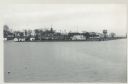
| Date: | 12 09 1957 |
|---|---|
| Description: | Turning basin, view east from ex-Haas property. There is a water tower on the right, and houses, boathouses and other buildings are along the shoreline to ... |
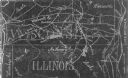
| Date: | 1954 |
|---|---|
| Description: | This photocopy map shows a early sketch of the settlement Southport. Rivers, lakes, other settlements, county boundaries, and roads are labeled. A portion ... |

| Date: | 1955 |
|---|---|
| Description: | Wind Point Lighthouse surrounded by outbuildings and framed by trees. Lake Michigan is in the distance. |
If you didn't find the material you searched for, our Library Reference Staff can help.
Call our reference desk at 608-264-6535 or email us at: