 Filter: Categories of Wisconsin Historical Images
Filter: Subject of Michigan, Lake
Filter: Year of 1900-1999
Filter: Year of 1920-1929
Filter: Categories of Wisconsin Historical Images
Filter: Subject of Michigan, Lake
Filter: Year of 1900-1999
Filter: Year of 1920-1929

| Date: | 1928 |
|---|---|
| Description: | This map shows the entire state of Wisconsin as well as portions of Michigan, Minnesota, Iowa and Illinois. Lake Michigan, Lake Superior, Lake Winnebago a... |
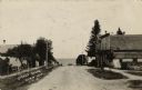
| Date: | 1922 |
|---|---|
| Description: | View of a small town street headed toward Lake Michigan. Businesses are on the right, and dwellings are on the left. |

| Date: | 1925 |
|---|---|
| Description: | Marion Briggs is standing and posing wearing a swimming suit and bathing cap for a full-length photograph. On the reverse of the photograph is written: "He... |

| Date: | 07 02 1920 |
|---|---|
| Description: | Alfred Holt is standing on the beach, carrying several boxes under his arm. To his right is his father W.A. Holt. A group of eight women are sitting on the... |
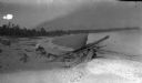
| Date: | 1920 |
|---|---|
| Description: | Ferdinand Leonard Hotz (Fedy, son of Ferdinand) is sitting on the shoreline of Europe Bay on Lake Michigan near a log. There is a section of a shipwreck on... |

| Date: | 1922 |
|---|---|
| Description: | Text on front reads: "Aerial View of Sheboygan, Wis." The image shows the Sheboygan River from Lake Michigan to the Pennsylvania Avenue bridge. |

| Date: | 1921 |
|---|---|
| Description: | A plat map of Mequon, Wisconsin. Text at top reads: "T. 9N. R.21 E MEQUON T. 9N. R.22 E." |
If you didn't find the material you searched for, our Library Reference Staff can help.
Call our reference desk at 608-264-6535 or email us at: