 Filter: Categories of Wisconsin Historical Images
Filter: Subject of Michigan, Lake
Filter: Year of 1900-1999
Filter: Year of 1920-1929
Filter: Categories of Wisconsin Historical Images
Filter: Subject of Michigan, Lake
Filter: Year of 1900-1999
Filter: Year of 1920-1929

| Date: | 1923 |
|---|---|
| Description: | This map includes an explanation that reads: "This chart shows the movement of barley on the Great Lakes, St. Lawrence River, and New York State Barge Cana... |

| Date: | 1923 |
|---|---|
| Description: | This map shows major cities surrounding the Great Lakes. Portions of Minnesota, Iowa, Illinois, Indiana, Ohio, Michigan, New York, Vermont, Massachusetts,C... |

| Date: | 1923 |
|---|---|
| Description: | This map includes an explanation that reads: "This chart shows the movement of corn on the Great Lakes, St. Lawrence River, and New York State Barge Canal ... |

| Date: | 1923 |
|---|---|
| Description: | This map includes an explanation that reads: "This chart shows the easterly movement of flaxseed on the Great Lakes, St. Lawrence River, and New York State... |

| Date: | 1923 |
|---|---|
| Description: | This map includes an explanation that reads: "This chart shows the movement of grain on the Great Lakes, St. Lawrence River, and New York State Barge Canal... |

| Date: | 1923 |
|---|---|
| Description: | This map shows the movement of iron ore in parts of Minnesota, Wisconsin, and the Upper Peninsula of Michigan, and includes parts of Lake Superior, Green B... |

| Date: | 1923 |
|---|---|
| Description: | This map shows the movement of iron ore along the Great Lakes. Portions of Minnesota, Iowa, Wisconsin, Illinois, Indiana, Ohio, Michigan, New York, Vermont... |

| Date: | 1923 |
|---|---|
| Description: | This map includes an explanation that reads: "This chart shows the movement of oats on the Great Lakes, St. Lawrence River, and New York State Barge Canal ... |

| Date: | 1923 |
|---|---|
| Description: | This map includes an explanation that reads: "This chart shows the movement of rye on the Great Lakes, St. Lawrence River, and New York State Barge Canal d... |

| Date: | 1923 |
|---|---|
| Description: | This map shows the movement of stone to cities along the Great Lakes. Portions of Minnesota, Iowa, Wisconsin, Illinois, Indiana, Ohio, Michigan, New York, ... |

| Date: | 1923 |
|---|---|
| Description: | This map shows steamship lines and cities along the Great Lakes. Portions of Minnesota, Iowa, Wisconsin, Illinois, Indiana, Ohio, Michigan, New York, Vermo... |

| Date: | 1923 |
|---|---|
| Description: | This map shows steamship lines and cities along the Great Lakes. Portions of Minnesota, Wisconsin, Illinois, Indiana, Ohio, Michigan, New York, Vermont, Ma... |

| Date: | 1923 |
|---|---|
| Description: | This map shows portions of Minnesota, Iowa, Wisconsin, Illinois, Indiana, Ohio, Michigan, New York, Vermont, Massachusetts, Connecticut, Ontario, and Quebe... |

| Date: | 1923 |
|---|---|
| Description: | This map shows portions of Minnesota, Iowa, Wisconsin, Illinois, Indiana, Ohio, Michigan, New York, Vermont, Massachusetts, Connecticut, Ontario, and Quebe... |

| Date: | 1926 |
|---|---|
| Description: | This brochure was intended for tourists and shows resorts, lakes and railroads in northwestern Wisconsin and part of Michigan’s upper peninsula. Also inclu... |

| Date: | 1925 |
|---|---|
| Description: | This map shows lakes, islands and bays. The Upper Peninsula of Michigan and Ontario are labeled. Three inset maps include the Upper end of St. Marys River ... |

| Date: | 1923 |
|---|---|
| Description: | This map includes an explanation that reads: "This chart shows the movement of wheat on the Great Lakes, St. Lawrence River, and New York State Barge Canal... |

| Date: | 1925 |
|---|---|
| Description: | This map shows the state trunk highway system and county trunk highways. The lower left corner includes a legend of roadway types. Lake Michigan and Lake S... |
| Date: | 1925 |
|---|---|
| Description: | This map shows the state trunk highway system and county trunk highways. The lower left corner includes a legend of roadway types. Lake Michigan and Lake S... |

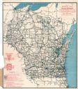
| Date: | 1926 |
|---|---|
| Description: | This map shows the state trunk highway system and county trunk highways. The lower left corner includes a legend of roadway types. Lake Michigan and Lake S... |
If you didn't find the material you searched for, our Library Reference Staff can help.
Call our reference desk at 608-264-6535 or email us at: