 Filter: Categories of Wisconsin Historical Images
Filter: Subject of Michigan, Lake
Filter: Year of 1900-1999
Filter: Year of 1910-1919
Filter: Categories of Wisconsin Historical Images
Filter: Subject of Michigan, Lake
Filter: Year of 1900-1999
Filter: Year of 1910-1919

| Date: | 1915 |
|---|---|
| Description: | This map shows wards, railroads, street railways, streets, lot and block numbers, parks, and hospitals. Also included are manuscript annotations of points ... |

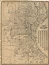
| Date: | 1911 |
|---|---|
| Description: | This map shows ward numbers, streets, railroads, electric car lines, parks, steam railways, section numbers, Lake Michigan and one mile concentric circles ... |

| Date: | 1912 |
|---|---|
| Description: | This map shows ward numbers, streets, railroads, electric car lines, parks, steam railways, section numbers, Lake Michigan and one mile concentric circles ... |

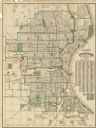
| Date: | 1911 |
|---|---|
| Description: | This map shows city wards, block numbers, parks, cemeteries, roads, railroads, Lake Michigan, and selected buildings. Also included are indexes "Milwaukee ... |

| Date: | 1916 |
|---|---|
| Description: | This map shows ward numbers, streets, railroads, electric car lines, parks, steam railways, section numbers, rivers, Lake Michigan, churches, schools, and ... |
| Date: | 1916 |
|---|---|
| Description: | This map shows wards, roads, railroads, parks, cemeteries, select buildings, and Lake Michigan. Also included is a street index and manuscript annotations ... |
| Date: | 1918 |
|---|---|
| Description: | This map shows wards, roads, railroads, parks, cemeteries, select buildings, and Lake Michigan. Also included is a street index. Cemeteries and parks are i... |

| Date: | 1910 |
|---|---|
| Description: | This ink on paper blue line print base map consists of eight separate pieces and shows city limits, The Milwaukee Electric Railroad & Light Company lines, ... |

| Date: | 1912 |
|---|---|
| Description: | This map shows counties, roads, Lake Superior, Lake Michigan, and a portion of Illinois, Iowa, Minnesota, and Michigan. Also included is a list of railroad... |

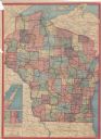
| Date: | 1915 |
|---|---|
| Description: | This map shows the extent of Wisconsin and pre-Wisconsin drift. The bottom left of the map includes a map categorizing the colors used into geologic period... |

| Date: | 1910 |
|---|---|
| Description: | This map shows counties, roads, Lake Superior, Lake Michigan, and portions of surrounding states. Also included is a list of railroads showing miles and gr... |

| Date: | 1914 |
|---|---|
| Description: | This map shows counties, roads, Lake Superior, Lake Michigan, and portions of surrounding states. Also included is a list of railroads showing miles and gr... |

| Date: | 1910 |
|---|---|
| Description: | This map shows counties, roads, Lake Superior, Lake Michigan, and portions of surrounding states. Included is a table of interstate and intrastate railroa... |
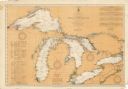
| Date: | 08 30 1911 |
|---|---|
| Description: | Chart showing all of the Great Lakes: Lake Superior, Lake Michigan, Lake Huron, Lake Erie, and Lake Ontario and canals, rivers and cities that border the l... |

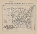
| Date: | 1914 |
|---|---|
| Description: | This map shows main traveled routes. Portions of Lake Michigan, Lake Superior, Illinois, Iowa, Michigan and Minnesota are labeled. Also includes a legend s... |

| Date: | 1916 |
|---|---|
| Description: | This map shows highways, roads, routes, communities, rivers, and lakes. Wide red lines show principle highways. Narrow red lines show secondary roadways or... |

| Date: | 1919 |
|---|---|
| Description: | Narrow red lines show principal secondary highways. Green circles shows points of historical interest. Green triangles show Indian mounds and Indian villag... |

| Date: | 1910 |
|---|---|
| Description: | A Sanborn insurance map of Milwaukee, including the shore of Lake Michigan. |
| Date: | 1913 |
|---|---|
| Description: | This map shows automobile roads, cities, county boundaries, rivers, lakes, railroads, electric lines, and congressional districts. Included are portions of... |
| Date: | 1916 |
|---|---|
| Description: | The map on the front shows roads from Madison to northern Illinois and as far north as St. Croix, Chippewa, Marathon, and Shawano counties. The map on the ... |
If you didn't find the material you searched for, our Library Reference Staff can help.
Call our reference desk at 608-264-6535 or email us at: