Filter: Categories of Wisconsin Historical Images
Filter: Subject of Michigan, Lake
Filter: Year of 1900-1999
Filter: Subject of transportation
Filter: Year of 1950-1959
Filter: Categories of Wisconsin Historical Images
Filter: Subject of Michigan, Lake
Filter: Year of 1900-1999
Filter: Subject of transportation
Filter: Year of 1950-1959
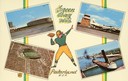
| Date: | 1957 |
|---|---|
| Description: | Composite image of "Packerland U.S.A." including prominent attractions: Lambeau Field, home of the Green Bay Packers, NFL Football team; the Brown County A... |
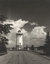
| Date: | 1954 |
|---|---|
| Description: | View down road towards the Fond du Lac lighthouse, built in 1933. There are cumulus clouds in the sky, and pine trees are lining the shore. |

| Date: | 1953 |
|---|---|
| Description: | View across water towards the Sturgeon Bay Canal Lighthouse, with a group of people in a motorboat in the foreground. |

| Date: | 1950 |
|---|---|
| Description: | An aerial view of town, showing a major industrial area. |

| Date: | 1951 |
|---|---|
| Description: | Aerial view of Jones Island and garbage disposal plant. |

| Date: | 1950 |
|---|---|
| Description: | Harbor area of Jones Island and garbage disposal plant, Stratton Grain Co., and more. |

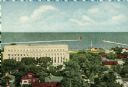
| Date: | 1953 |
|---|---|
| Description: | Aerial view looking north from the foot of Milwaukee's main thoroughfare, Wisconsin Avenue. Lincoln Memorial Drive winds its way along the lagoon in Juneau... |

| Date: | 1950 |
|---|---|
| Description: | A map from the Wisconsin identifying the locations airports and other landing facilities in the state. On the opposite side the map includes an alphabetica... |

| Date: | 1950 |
|---|---|
| Description: | This road map shows federal, state and county roads in Wisconsin, northern Illinois, northeastern Iowa, eastern Minnesota, and the western portion of Michi... |

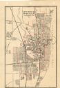
| Date: | 1950 |
|---|---|
| Description: | This map is accompanied by booklet: "Know Milwaukee Map and Street Guide". The map is a detailed map of Milwaukee and the surrounding suburbs. Streets and ... |

| Date: | 1951 |
|---|---|
| Description: | Water depths shown by bathymetric tints, isolines, and soundings. Relief shown by contours. "Soundings in feet." "Aids to navigation corrected to May 4, 19... |

| Date: | 1951 |
|---|---|
| Description: | Water depths shown by bathymetric tints and soundings. Relief shown by contours. "Depths in feet." "Aids to navigation corrected to May 4, 1951." On verso:... |

| Date: | 1950 |
|---|---|
| Description: | This map of Sturgeon Bay is part of the survey of the northern and northwestern lakes. The map shows lights, railroads, roads, and some public buildings. R... |

| Date: | 1956 |
|---|---|
| Description: | This map of Racine includes a street directory and index of public buildings. Streets, points of interest, Lake Michigan, and the Root River are labeled. A... |

| Date: | 1951 |
|---|---|
| Description: | This map of Racine Harbor has relief shown by contours and depths shown by gradient tints and soundings in feet. The map also shows Racine Reef, Wind Point... |

| Date: | 1953 |
|---|---|
| Description: | This map is a blue line print and shows streets as well as some points of interest. |
| Date: | 1950 |
|---|---|
| Description: | This map shows streets and waterways and includes annotations in red outlining wards. |

| Date: | 1956 |
|---|---|
| Description: | This maps shows voting precincts and polling places as well as wards. Streets and the Sheboygan River are labeled. The bottom right of the map features a l... |
If you didn't find the material you searched for, our Library Reference Staff can help.
Call our reference desk at 608-264-6535 or email us at: