Filter: Categories of Wisconsin Historical Images
Filter: Subject of Michigan, Lake
Filter: Year of 1900-1999
Filter: Subject of transportation
Filter: Categories of Wisconsin Historical Images
Filter: Subject of Michigan, Lake
Filter: Year of 1900-1999
Filter: Subject of transportation

| Date: | 1941 |
|---|---|
| Description: | Official highway map of Wisconsin, "the playground of the Midwest," showing the state transportation network prior to World War II. |
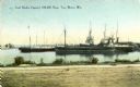
| Date: | 1900 |
|---|---|
| Description: | View from shoreline towards the coal docks on the right, with several ships in the harbor. Caption reads: "Coal Docks, Capacity 100,000 Tons, Two Rivers, W... |
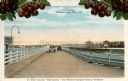
| Date: | 1920 |
|---|---|
| Description: | View of two automobiles crossing a toll bridge. There are cherries on branches at the top of the postcard. Caption reads: "In Door County 'Cherryland,' The... |

| Date: | 1953 |
|---|---|
| Description: | View across water towards the Sturgeon Bay Canal Lighthouse, with a group of people in a motorboat in the foreground. |
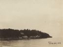
| Date: | 1910 |
|---|---|
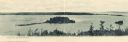
| Description: | View of Sawyer Harbor as seen from Government Bluff. |
| Date: | 1910 |
|---|---|
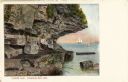
| Description: | View of Lover's Leap, with a group of people posing on the rocks and sailboats in the background. Caption reads: "Lover's Leap, Sturgeon Bay, Wis." |
| Date: | 1910 |
|---|---|
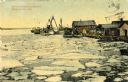
| Description: | A springtime harbor scene from Sturgeon Bay. Chunks of ice are floating on the surface of the water. Caption reads: "Harbor scene at springtime. Sturgeon B... |

| Date: | 1950 |
|---|---|
| Description: | An aerial view of town, showing a major industrial area. |
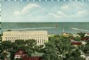
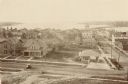
| Date: | 1909 |
|---|---|
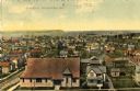
| Description: | Elevated view of the First Ward. Caption reads: "First Ward, Sturgeon Bay, Wis." |

| Date: | 1915 |
|---|---|
| Description: | View of the Sturgeon Bay ship canal. Caption reads: "Sturgeon Bay Ship Canal." |

| Date: | 1913 |
|---|---|
| Description: | View of the canal. Caption reads: "The Canal, Stugeon[sic] Bay, Wis." |

| Date: | 1909 |
|---|---|
| Description: | View of a boating scene off of the shore of Marinette and Menominee. Two boys are walking on the pier on the left, and a crowd of people are gathered at th... |
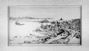
| Date: | 1900 |
|---|---|
| Description: | View across water of a dock and buildings on Lake Michigan. |
| Date: | 1910 |
|---|---|
| Description: | Elevated view of various buildings with Sturgeon Bay in the background. |
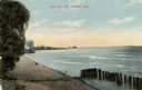
| Date: | 1910 |
|---|---|
| Description: | View of the main pier and harbor lighthouse from the Lake Michigan shoreline. Caption reads: "Bay and Pier, Racine, Wis." |

| Date: | 04 01 1975 |
|---|---|
| Description: | The bridge over the Milwaukee Harbor named in honor of former Mayor Daniel Hoan. The bridge was constructed between 1970 and 1972, but during the period de... |

| Date: | 1909 |
|---|---|
| Description: | [Lithography] by Poole Bros. Contains descriptive information. Short jaunts for busy people to nearby resorts in Illinois and Wisconsin. |

| Date: | 1910 |
|---|---|
| Description: | Wisconsin Geological and Natural History Survey, by Lawrence Martin reproduced from a model of the state prepared by W.O. Hotchkiss and F.T. Thwaites and m... |
If you didn't find the material you searched for, our Library Reference Staff can help.
Call our reference desk at 608-264-6535 or email us at: