 Filter: Categories of Wisconsin Historical Images
Filter: Subject of Michigan, Lake
Filter: Year of 1900-1999
Filter: Community of Milwaukee
Filter: Year of 1900-1909
Filter: Categories of Wisconsin Historical Images
Filter: Subject of Michigan, Lake
Filter: Year of 1900-1999
Filter: Community of Milwaukee
Filter: Year of 1900-1909

| Date: | 1906 |
|---|---|
| Description: | Polyconic projection. Map made from surveys without spirit level control. Henry Gannett, Chief Topographer. Topography by Van H. Manning and Nat. Tyler, Jr... |
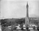
| Date: | 06 19 1902 |
|---|---|
| Description: | Elevated view of the North Point Water Tower at the foot of E. North Avenue. |
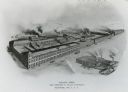
| Date: | 1900 |
|---|---|
| Description: | Main factory with South Foundry in lower left. Lake Michigan is in the background. Later the Allis-Chalmers Manufacturing Co. |
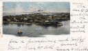
| Date: | 1902 |
|---|---|
| Description: | Elevated view of island with houses and boathouses and boats along the shoreline. Industrial buildings are in the background, and a sailboat is on the wate... |
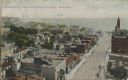
| Date: | 1909 |
|---|---|
| Description: | Elevated view of Wisconsin Street, looking east from the Post Office towards Lake Michigan. Date written in pencil on postcard reads May 21, 1909. Caption ... |
| Date: | 1905 |
|---|---|
| Description: | Elevated view of people walking on a path by the Whitefish Bay Resort along the lake front. Caption reads: "Whitefish Bay Resort, Milwaukee." |

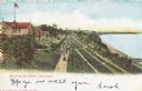
| Date: | 1905 |
|---|---|
| Description: | Elevated view of Water Tower and park with Milwaukee Bay in background. Caption reads: "Water Tower and Park with view of Milwaukee Bay, Milwaukee." |
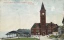
| Date: | 1904 |
|---|---|
| Description: | The station with the clock tower is on the right, and the tracks and train shed are on the left. Pedestrians are on the lawn nearby, and houses are on the ... |
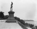
| Date: | 09 1900 |
|---|---|
| Description: | View of a statue in Juneau Park, created by American sculptor Anne Whitney in 1887. The statue is a replica of the original which resides in Boston, Massac... |
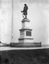
| Date: | 09 1900 |
|---|---|
| Description: | View of the Solomon Juneau statue in Juneau Park, erected in 1890. |

| Date: | 1902 |
|---|---|
| Description: | A map of Milwaukee County, Wisconsin that shows the township and range system, sections, towns, roads, railroads and rail stations, cities and villages, po... |

| Date: | 1902 |
|---|---|
| Description: | Map reads: "Milwaukee's Polish Population. Map showing in Red Color the Location and Density of Polish=Speaking Population of the City of Milwaukee, Wis." ... |

| Date: | 1900 |
|---|---|
| Description: | Map shows 6 types of zoning districts in Milwaukee township. There is a key identifying four types of land: "AGRICULTURAL," '"A" RESIDENCE.' '"B" RESIDENCE... |

| Date: | 1902 |
|---|---|
| Description: | Two-wheeled show cart with pair of white show horses in tandem hitch, being driven by one person, probably along Lake Michigan. |
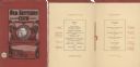
| Date: | 02 22 1902 |
|---|---|
| Description: | Front cover and menu page of the annual banquet of the Old Settlers' Club of Milwaukee County. On the cover is an oval tipped-in portrait of club president... |

| Date: | 1900 |
|---|---|
| Description: | This map shows city wards, block numbers, parks, cemeteries, roads, railroads, Lake Michigan, and selected buildings. Also included are indexes "Milwaukee ... |

| Date: | 1901 |
|---|---|
| Description: | This map shows public schools, engine houses, railroads, street railways, city wards, parks, block numbers, and Lake Michigan. Also included are indexes, t... |

| Date: | 1901 |
|---|---|
| Description: | This map shows city wards, block numbers, parks, cemeteries, roads, railroads, Lake Michigan, and selected buildings. Also included are indexes "Milwaukee ... |

| Date: | 1902 |
|---|---|
| Description: | This map is a chart of Milwaukee Harbor that displays local streets, bridges, roads, railroads, public buildings, businesses, factories, dry docks, parks, ... |

| Date: | 1906 |
|---|---|
| Description: | This map shows wards, schools, engine houses, railroads, street railways, block numbers, parks, roads, and Lake Michigan. Also included are indexes: Table ... |
If you didn't find the material you searched for, our Library Reference Staff can help.
Call our reference desk at 608-264-6535 or email us at: