 Filter: Categories of Wisconsin Historical Images
Filter: Subject of Michigan, Lake
Filter: Year of 1900-1999
Filter: Type of Map or Atlas
Filter: Year of 1970-1979
Filter: Categories of Wisconsin Historical Images
Filter: Subject of Michigan, Lake
Filter: Year of 1900-1999
Filter: Type of Map or Atlas
Filter: Year of 1970-1979

| Date: | 1970 |
|---|---|
| Description: | A map of parks of Kewaunee County, Wisconsin, showing the fishing spots, lakes and parks in the area, it also provides a location map of the area. On the ... |
| Date: | 1977 |
|---|---|
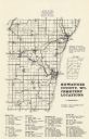
| Description: | A map of Kewaunee County, Wisconsin that identifies the locations of 46 cemeteries in the county. The cemeteries are listed by town. |

| Date: | 1972 |
|---|---|
| Description: | These maps show the Milwaukee County supervisory districts as of April 1972 and the Supervisor and Assembly districts in effect prior to the April 1972 ele... |

| Date: | 1976 |
|---|---|
| Description: | A street map of Milwaukee County, Wisconsin that identifies the location of schools, hospitals, parks, beaches, streets, freeways, both planned or under co... |

| Date: | 1976 |
|---|---|
| Description: | This hand-colored map shows land divided by forest type and tree species. Also shown are counties, Lake Michigan, Lake Superior, Lake Winnebago, and the Mi... |

| Date: | 1974 |
|---|---|
| Description: | Map of Wisconsin with drawings illustrating historic places and events throughout the state. The Great Seal of the State of Wisconsin appears at the top ri... |

| Date: | 1975 |
|---|---|
| Description: | This map provides an index of quadrangle maps for the state. The lower left corner contains explanation land surveying completeness. Communities, counties,... |

| Date: | 1975 |
|---|---|
| Description: | This map provides an index of outdated quadrangle maps for the state. Communities, counties, rivers, and lakes are labeled including Lake Michigan and Lake... |
If you didn't find the material you searched for, our Library Reference Staff can help.
Call our reference desk at 608-264-6535 or email us at: