 Filter: Categories of Wisconsin Historical Images
Filter: Subject of Michigan, Lake
Filter: Year of 1900-1999
Filter: Type of Map or Atlas
Filter: Year of 1960-1969
Filter: Categories of Wisconsin Historical Images
Filter: Subject of Michigan, Lake
Filter: Year of 1900-1999
Filter: Type of Map or Atlas
Filter: Year of 1960-1969

| Date: | 1968 |
|---|---|
| Description: | This map shows lakes, rivers and soil types. Lake Michigan, Lake Superior, and portions of Illinois, Iowa, Michigan, and Minnesota are labeled. A legend to... |

| Date: | 1969 |
|---|---|
| Description: | This Post Office Department map identifies post offices, summer post offices, rural stations, highway post offices, Post Office sectional centers, rural de... |

| Date: | 1966 |
|---|---|
| Description: | This map from the 1960s provides a detailed street map of Milwaukee County and eastern Waukesha County as far west as Menomonee Falls and Muskego Lake. A p... |

| Date: | 1968 |
|---|---|
| Description: | A tourist map of Milwaukee County and of downtown Milwaukee. The Map of Milwaukee County identifies the location of some of the points of interests in the ... |

| Date: | 1965 |
|---|---|
| Description: | A map of Milwaukee County showing the county supervisor districts and the city wards. The map also includes the names of those on the on the board of elect... |

| Date: | 1960 |
|---|---|
| Description: | Color coded map in pink, yellow, blue, and brown of Milwaukee County State and County trunk highways. The map includes a legend of symbols: "STEAM RAIL ROA... |

| Date: | 1961 |
|---|---|
| Description: | This map shows streets and some points of interest. Kewaunee River and Lake Michigan are both labeled. |

| Date: | 1961 |
|---|---|
| Description: | This is a photocopy of a map in blue line print that shows streets and places of interest. Inscribed in pen, at the bottom of the map, reads: "Sen. Zaborsk... |
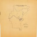
| Date: | 08 1964 |
|---|---|
| Description: | This map shows the city limits, Lake Michigan, the Manitowoc River, Silver Creek, designated sample sites with manuscript annotations, central business dis... |

| Date: | 1965 |
|---|---|
| Description: | This map shows wards, city limits, railroad right of way, proposed future streets, and approximate street elevations. Wards and public schools are labeled ... |

| Date: | 1965 |
|---|---|
| Description: | This map is indexed for public buildings and includes a numbered key on the lower left side. The streets are labeled and Lake Michigan is labeled on the fa... |
| Date: | 1965 |
|---|---|
| Description: | This map shows 8 zoning districts, as well as house number system, schools, parks, churches, and points of interest. Lake Michigan is labeled and the lower... |
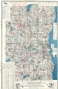
| Date: | 1960 |
|---|---|
| Description: | This map shows lakes arranged by county, depth maps of selected larger lakes, and enlargements of Mississippi River areas. The map also includes locations ... |

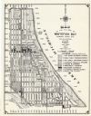
| Date: | 1966 |
|---|---|
| Description: | This map shows city, suburban, parochial and other types schools, with an explanation of symbols in the right margin. The original caption for the map read... |
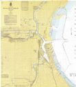
| Date: | 1967 |
|---|---|
| Description: | This map shows the harbor, streets, and some buildings. Also includes the Menomonee River, the Kinnickinnic River, the Municipal mooring Basin, and Lake Mi... |

| Date: | 1965 |
|---|---|
| Description: | This series of 17 maps show boundaries and changes in city limits from 1846 to 1965. The base of all of the maps are the same, Milwaukee and suburbs. All m... |
If you didn't find the material you searched for, our Library Reference Staff can help.
Call our reference desk at 608-264-6535 or email us at: