Filter: Categories of Wisconsin Historical Images
Filter: Subject of Michigan, Lake
Filter: Subject of human settlements
Filter: Categories of Wisconsin Historical Images
Filter: Subject of Michigan, Lake
Filter: Subject of human settlements

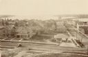
| Date: | 1856 |
|---|---|
| Description: | View of Manitowoc from the north side. |

| Date: | 1909 |
|---|---|
| Description: | View of a boating scene off of the shore of Marinette and Menominee. Two boys are walking on the pier on the left, and a crowd of people are gathered at th... |
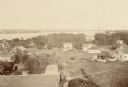
| Date: | 1900 |
|---|---|
| Description: | View across water of a dock and buildings on Lake Michigan. |
| Date: | 1909 |
|---|---|
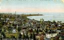
| Description: | Elevated view of town on Lake Michigan. Caption reads: "Sheboygan, Wis. North Point on Lake Michigan." |
| Date: | 1910 |
|---|---|
| Description: | Elevated view of various buildings with Sturgeon Bay in the background. |
| Date: | 1910 |
|---|---|
| Description: | Elevated view of Sturgeon Bay with multiple buildings in the foreground. |

| Date: | 1848 |
|---|---|
| Description: | Immigrant map. |

| Date: | 1865 |
|---|---|
| Description: | Map showing the location of meteorological stations and effects that Lake Michigan has had on Wisconsin temperatures in January and July. The map shows cou... |

| Date: | 1838 |
|---|---|
| Description: | Compiled from the latest authorities. Published by Hinman and Dutton. |
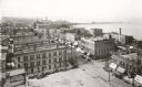
| Date: | 1898 |
|---|---|
| Description: | Elevated view of the downtown area looking northeast from the courthouse corner. |
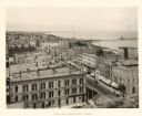
| Date: | 1888 |
|---|---|
| Description: | Elevated view from the Racine Court House of northeast Racine, with Lake Michigan on the right. Caption reads: "Bird's-Eye from Court House." |
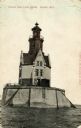
| Date: | |
|---|---|
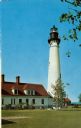
| Description: | View of the Reef Lighthouse. Caption reads: "Racine Reef Light House, Racine, Wis." |

| Date: | 1932 |
|---|---|
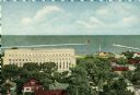
| Description: | View of Lake Michigan from Memorial Hall. Caption reads: "Lake Michigan from Memorial Hall, Racine, Wisconsin". |
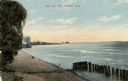
| Date: | 1910 |
|---|---|
| Description: | View of the main pier and harbor lighthouse from the Lake Michigan shoreline. Caption reads: "Bay and Pier, Racine, Wis." |

| Date: | 1880 |
|---|---|
| Description: | This map shows railroads by operator and projected railroads. Portions of Lake Michigan, Lake Superior, Illinois, Iowa, Michigan and Minnesota are labeled. |

| Date: | 04 01 1975 |
|---|---|
| Description: | The bridge over the Milwaukee Harbor named in honor of former Mayor Daniel Hoan. The bridge was constructed between 1970 and 1972, but during the period de... |

| Date: | 1909 |
|---|---|
| Description: | [Lithography] by Poole Bros. Contains descriptive information. Short jaunts for busy people to nearby resorts in Illinois and Wisconsin. |

| Date: | 1876 |
|---|---|
| Description: | Made from U.S. Surveys and from minutes furnished by Jos. S. Buck and Dr. C. Chase. Scale 20 CHs to an inch. |
If you didn't find the material you searched for, our Library Reference Staff can help.
Call our reference desk at 608-264-6535 or email us at: