Filter: Categories of Wisconsin Historical Images
Filter: Subject of Michigan, Lake
Filter: County of Sheboygan
Filter: Creator Name of Unknown
Filter: Categories of Wisconsin Historical Images
Filter: Subject of Michigan, Lake
Filter: County of Sheboygan
Filter: Creator Name of Unknown
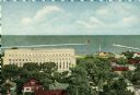
| Date: | 1909 |
|---|---|
| Description: | Elevated view of town on Lake Michigan. Caption reads: "Sheboygan, Wis. North Point on Lake Michigan." |

| Date: | 1934 |
|---|---|
| Description: | This 1930s highway map of Sheboygan County, Wisconsin, shows roads, the township and range grid, towns, sections, cities and villages, and streams, lakes, ... |

| Date: | 1840 |
|---|---|
| Description: | This is a plat map of Sheboygan showing the Sheboygan River and Lake Michigan. Streets are labeled and plats are numbered in quadrants. Some points of inte... |

| Date: | 1857 |
|---|---|
| Description: | This map shows piers, wharves, streets, and the lake shore from the survey of August 1856. Lake Michigan and the Sheboygan River are labeled. Depths are sh... |
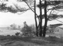
| Date: | 1938 |
|---|---|
| Description: | View down slope towards a pine tree with three main trunks silhouetted against rolling dunes on the shore of Lake Michigan. |
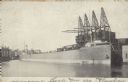
| Date: | 10 17 1906 |
|---|---|
| Description: | Text on front reads: "Harbor View - Sheboygan, Wis." A lake freighter, or "laker" is docked at the harbor. |
If you didn't find the material you searched for, our Library Reference Staff can help.
Call our reference desk at 608-264-6535 or email us at: