Filter: Categories of Wisconsin Historical Images
Filter: Subject of Michigan, Lake
Filter: Community of Sturgeon Bay
Filter: Subject of human settlements
Filter: Categories of Wisconsin Historical Images
Filter: Subject of Michigan, Lake
Filter: Community of Sturgeon Bay
Filter: Subject of human settlements

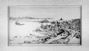
| Date: | 1893 |
|---|---|
| Description: | Bird's-eye map of Sturgeon Bay, looking Northeast. Area bordered by Church Street in top left corner, leather & Smith Bridge in bottom left corner, Lawrenc... |
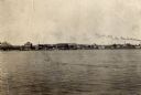
| Date: | 1914 |
|---|---|
| Description: | View of Sturgeon Bay with the Teweles & Brandeis flour mill across the water on the left. |
| Date: | |
|---|---|
| Description: | View of a U.S. lighthouse and Coast Guard station. |
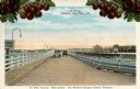
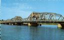
| Date: | 1920 |
|---|---|
| Description: | View of two automobiles crossing a toll bridge. There are cherries on branches at the top of the postcard. Caption reads: "In Door County 'Cherryland,' The... |

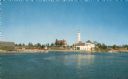
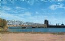
| Date: | 1953 |
|---|---|
| Description: | View across water towards the Sturgeon Bay Canal Lighthouse, with a group of people in a motorboat in the foreground. |

| Date: | 1907 |
|---|---|
| Description: | The Ruins of the old Light House on Plum Island near Sturgeon Bay. Caption at bottom reads: "Ruins of Old Light House on Plum Island," "Made expressly for ... |
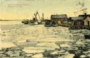
| Date: | 1910 |
|---|---|
| Description: | A springtime harbor scene from Sturgeon Bay. Chunks of ice are floating on the surface of the water. Caption reads: "Harbor scene at springtime. Sturgeon B... |
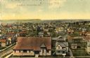
| Date: | 1909 |
|---|---|
| Description: | Elevated view of the First Ward. Caption reads: "First Ward, Sturgeon Bay, Wis." |

| Date: | 1915 |
|---|---|
| Description: | View of the Sturgeon Bay ship canal. Caption reads: "Sturgeon Bay Ship Canal." |

| Date: | 1913 |
|---|---|
| Description: | View of the canal. Caption reads: "The Canal, Stugeon[sic] Bay, Wis." |
| Date: | |
|---|---|
| Description: | View of the bridge spanning the Sturgeon Bay canal. |
| Date: | |
|---|---|
| Description: | View from the shoreline of a bridge spanning the Sturgeon Bay canal. |
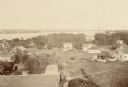
| Date: | 1910 |
|---|---|
| Description: | Elevated view of Sturgeon Bay with multiple buildings in the foreground. |
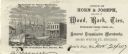
| Date: | |
|---|---|
| Description: | Letterhead of the Horn's Pier (Door County) office of Horn & Joseph, dealers in general merchandise, including "Wood, Bark, Ties, Telegraph Poles, Posts, &... |

| Date: | 1950 |
|---|---|
| Description: | This map of Sturgeon Bay is part of the survey of the northern and northwestern lakes. The map shows lights, railroads, roads, and some public buildings. R... |
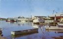
| Date: | 1958 |
|---|---|
| Description: | View from pier of Peterson's Boat Works in Sturgeon Bay. |

| Date: | 06 25 1901 |
|---|---|
| Description: | This map shows beacons, buoys, docks, quarries, streets, and buildings. The map inset shows the Harbor of refuge at entrance to Sturgeon Bay and Lake Michi... |

| Date: | 12 28 1908 |
|---|---|
| Description: | This map shows beacons, buildings, streets, and quarries. Two inset maps include: Vicinity of Sturgeon Bay, Wis. and the Harbor of refuge at entrance to St... |

| Date: | 01 06 1958 |
|---|---|
| Description: | View from jetty out towards Lake Michigan entrance to Ship Canal. A large tank, streetlamp and buildings are on the left. On the opposite jetty is a lighth... |
If you didn't find the material you searched for, our Library Reference Staff can help.
Call our reference desk at 608-264-6535 or email us at: