 Filter: Categories of Wisconsin Historical Images
Filter: Subject of Michigan, Lake
Filter: Community of Manitowoc
Filter: Subject of cities and towns
Filter: Categories of Wisconsin Historical Images
Filter: Subject of Michigan, Lake
Filter: Community of Manitowoc
Filter: Subject of cities and towns

| Date: | 1883 |
|---|---|
| Description: | Bird's-eye map of Manitowoc. |

| Date: | 1905 |
|---|---|
| Description: | Bird's-eye view of Manitowoc on the shores of Lake Michigan. A map of the northeastern part of the United States at the top indicates Manitowoc's location ... |

| Date: | 05 15 1897 |
|---|---|
| Description: | Elevated view of the Chicago & Northwestern Railway yards looking northwest. The elevator of the Northern Grain Company is in the middle distance. |

| Date: | 1950 |
|---|---|
| Description: | An aerial view of town, showing a major industrial area. |

| Date: | 1856 |
|---|---|
| Description: | View of Manitowoc from the north side. |
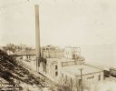
| Date: | 1927 |
|---|---|
| Description: | View from a hill looking down on the plant which has several attached buildings, and a large chimney. To the right are railroad cars along the shoreline o... |

| Date: | |
|---|---|
| Description: | Letterhead of the William Rahr Sons' Company of Manitowoc, Wisconsin, "Maltsters and Roasters," with an elevated view of the company building on one side o... |

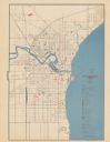
| Date: | 01 1899 |
|---|---|
| Description: | Shows lot and block numbers, railroads, ward boundaries, and some landownership. Includes public building index. |
| Date: | 1945 |
|---|---|
| Description: | Map features a legend with symbols of points of interest. The symbols are in red. The back of the map has text on "Points of Interest and Information". |

| Date: | 1951 |
|---|---|
| Description: | Water depths shown by bathymetric tints, isolines, and soundings. Relief shown by contours. "Soundings in feet." "Aids to navigation corrected to May 4, 19... |

| Date: | 01 08 1958 |
|---|---|
| Description: | Elevated view over icy water towards ships in the shipyard on the left, and the cement company in the background. Cranes and industrial buildings are in th... |

| Date: | 1905 |
|---|---|
| Description: | This map shows a plat of the city, local streets, railroads, public buildings, local businesses, and parts of the Manitowoc River and Lake Michigan. Relief... |

| Date: | |
|---|---|
| Description: | This plat map shows numbered blocks and lots, wards, local streets, railroads, cemeteries, buildings, land ownership by name, and parts of Manitowoc River ... |

| Date: | 1925 |
|---|---|
| Description: | This map shows a plat of the city, local streets, railroads, public buildings, local businesses, and parts of the Manitowoc River and Lake Michigan. Relief... |
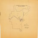
| Date: | 08 1964 |
|---|---|
| Description: | This map shows the city limits, Lake Michigan, the Manitowoc River, Silver Creek, designated sample sites with manuscript annotations, central business dis... |

| Date: | 1856 |
|---|---|
| Description: | This map shows the Manitowoc River, Lake Michigan, streets, and buildings. Relief is shown by hachures and soundings are in feet and decimals of a foot. Th... |

| Date: | 09 1853 |
|---|---|
| Description: | This map shows streets, docks, warehouses, and piers near the harbor. The Manitowoc River and Lake Michigan are labeled. Depths are indicated by soundings ... |

| Date: | 1854 |
|---|---|
| Description: | This map shows streets, docks, warehouses, and piers near the harbor. Relief is shown by hachures and depths are shown by soundings and isolines. Lake Mich... |

| Date: | 1856 |
|---|---|
| Description: | This map shows streets, piers, and wharves. Lake Michigan, the Manitowoc River, and select buildings are labeled. Relief is shown by hachures and sounding... |
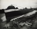
| Date: | 09 09 1954 |
|---|---|
| Description: | Elevated view of the sideways launching of Hull 418, the Detroit Edison at Manitowoc Shipbuilding, Inc. A group of people are gathered at the wharf ... |
If you didn't find the material you searched for, our Library Reference Staff can help.
Call our reference desk at 608-264-6535 or email us at: