 Filter: Categories of Wisconsin Historical Images
Filter: Subject of Michigan, Lake
Filter: Creator Name of Unknown
Filter: Categories of Wisconsin Historical Images
Filter: Subject of Michigan, Lake
Filter: Creator Name of Unknown
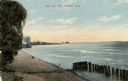
| Date: | 1910 |
|---|---|
| Description: | View of the main pier and harbor lighthouse from the Lake Michigan shoreline. Caption reads: "Bay and Pier, Racine, Wis." |

| Date: | 1835 |
|---|---|
| Description: | Constructed for the Topographical Bureau [Wash.], 1835. Scale: 16 miles to 1 inch. Map of a portion of the Indian country lying east and west of the Missis... |

| Date: | 04 01 1975 |
|---|---|
| Description: | The bridge over the Milwaukee Harbor named in honor of former Mayor Daniel Hoan. The bridge was constructed between 1970 and 1972, but during the period de... |

| Date: | 1916 |
|---|---|
| Description: | Southeastern Wisconsin which lies east of Whitewater and south of Port Washington. |

| Date: | 1954 |
|---|---|
| Description: | View looking west from Eagle Bluff toward Nicolet Bay, the Strawberry Islands, and Chambers Island. Three people are sitting on the stone wall of the overl... |

| Date: | 1960 |
|---|---|
| Description: | View across water towards the 180-foot high Eagle Bluff. The bluff received its name from the eagles which formerly nested there. |

| Date: | 1960 |
|---|---|
| Description: | View across water towards the 180-foot high Eagle Bluff. The bluff received its name from the eagles which formerly nested there. |
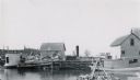
| Date: | |
|---|---|
| Description: | Dock with two steamboats and fishing implements in harbor. |
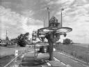
| Date: | 06 20 1966 |
|---|---|
| Description: | Falk caption reads, "A series of photos showing delivery of the first shipment of Radicon units direct from England to the port of Milwaukee. The series EG... |
| Date: | 08 24 1971 |
|---|---|
| Description: | Tramway that was used by O.D. Hopkins Association Incorporated of Contoocook, New Hampshire. Falk caption reads, "Tramway (Skylark- customers, Sky Glider) ... |

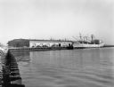
| Date: | 1950 |
|---|---|
| Description: | Harbor area of Jones Island and garbage disposal plant, Stratton Grain Co., and more. |
| Date: | |
|---|---|
| Description: | Aerial view looking north of downtown, with the Milwaukee River and Lake Michigan. |
| Date: | 1895 |
|---|---|
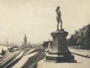
| Description: | Side view of the statue on a plinth with Celtic designs, with his right hand holding a horn resting on his hip. The statue is located in Juneau Park. On th... |

| Date: | 1940 |
|---|---|
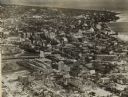
| Description: | Aerial view of city, river and harbor. Two smokestacks are on either side of the river mouth. |
| Date: | |
|---|---|
| Description: | Train station in the distance, with a man standing in the foreground on steps leading down to the lake, near a fenced-in pond. On the left are railroad tra... |

| Date: | 1940 |
|---|---|
| Description: | Monument in Juneau Park. A man is sitting on a bench, with Lake Michigan behind. |

| Date: | 1910 |
|---|---|
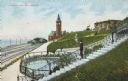
| Description: | Elevated view over trees and bushes toward the footbridge. A building with a red roof is on the far right. Beyond the bridge is Lake Michigan. Caption read... |
| Date: | 1910 |
|---|---|
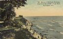
| Description: | Path along Lake Michigan beach. Below are people walking along the shoreline. Further down the path is a small group of people. Pilings are in the water in... |

| Date: | |
|---|---|
| Description: | View looking down toward a curving stairway leading down to a terrace with columns and ornate railings. In the background is a flagpole on the overlook to ... |

| Date: | 1889 |
|---|---|
| Description: | Looking down street toward Lake Michigan, which is visible at the end of the road. The dirt street is lined with trees and houses. On the right stands a... |
If you didn't find the material you searched for, our Library Reference Staff can help.
Call our reference desk at 608-264-6535 or email us at: