 Filter: Categories of Wisconsin Historical Images
Filter: Subject of Michigan, Lake
Filter: Creator Name of Unknown
Filter: Categories of Wisconsin Historical Images
Filter: Subject of Michigan, Lake
Filter: Creator Name of Unknown
| Date: | |
|---|---|
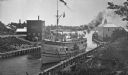
| Description: | Elevated view of the "City of Charlevoix" ship coming into harbor. The sign painted on the front of the ship reads: "Northern Michigan Line" and "City of C... |

| Date: | 1856 |
|---|---|
| Description: | A Wisconsin map showing the Wisconsin Superior and St. Croix Railroad. |

| Date: | |
|---|---|
| Description: | Elevated view toward a small boat landing and pier area on the shore of Lake Michigan. Many men, women and children are on the pier, and a house is on a hi... |

| Date: | |
|---|---|
| Description: | Elevated view of Sturgeon Bay with houses in the foreground. |

| Date: | |
|---|---|
| Description: | Elevated view of Sturgeon Bay showing commercial and domestic buildings in the foreground. Photograph made between 1916-1928. |

| Date: | |
|---|---|
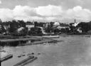
| Description: | Elevated view of Sturgeon Bay. The commercial strip and domestic buildings are in the foreground. |

| Date: | |
|---|---|
| Description: | View of Leathem D. Smith Stone Company, which expanded after 1918. A factory building is in the background, and a steam shovel is working in the foreground... |
| Date: | |
|---|---|
| Description: | View of Eagle Harbor and the area surrounding Church Street. On the right, Ephraim Moravian Church, completed in 1859, can be seen among residential buildi... |
| Date: | |
|---|---|
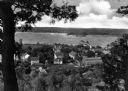
| Description: | View of a residential area of Fish Creek, looking out over Fish Creek Harbor. |
| Date: | |
|---|---|
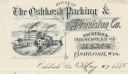
| Description: | Letterhead of the Oshkosh Packing & Provision Company, a meat packer and preserver, with an illustration of the company buildings on the waterfront, with w... |

| Date: | |
|---|---|
| Description: | Letterhead of the William Rahr Sons' Company of Manitowoc, Wisconsin, "Maltsters and Roasters," with an elevated view of the company building on one side o... |

| Date: | 1940 |
|---|---|
| Description: | This map of southeastern Wisconsin depicts the Rock and Milwaukee rivers and the Kettle Moraine area. Cities and villages are identified. Stamp stating "Po... |

| Date: | 1900 |
|---|---|
| Description: | A map of Wisconsin, eastern Minnesota and Iowa, northern Iowa, and Michigan’s Upper Peninsula, showing railway lines, with those marked with heavy red line... |

| Date: | 1856 |
|---|---|
| Description: | A map showing rail lines in Wisconsin and the railroad land grants of the Superior & St. Croix Railroad in the present-day northwestern Wisconsin counties ... |

| Date: | 1890 |
|---|---|
| Description: | A map of Wisconsin, eastern Wisconsin and Iowa, northern Illinois, and the Upper Peninsula of Michigan. The counties, cities and villages, and rail lines i... |

| Date: | |
|---|---|
| Description: | Memohead of the Green Bay Transportation Company, with a center image of a steamer traveling on the water and a life preserver on one side printed with the... |
| Date: | |
|---|---|
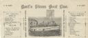
| Description: | Letterhead of Hart's Steam Boat Line of Green Bay, Wisconsin, with a steam boat named after the proprietor, C.W. Moore, with a flag bearing the same name. ... |
| Date: | |
|---|---|
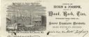
| Description: | Letterhead of the Horn's Pier (Door County) office of Horn & Joseph, dealers in general merchandise, including "Wood, Bark, Ties, Telegraph Poles, Posts, &... |

| Date: | |
|---|---|
| Description: | View from Lake Michigan towards the shoreline at Racine looking southwest. |

| Date: | 1860 |
|---|---|
| Description: | A hand-drawn, ink on cloth map of southeastern Wisconsin that show roads and railroads that connect Chicago to Milwaukee and other towns in the southeaster... |
If you didn't find the material you searched for, our Library Reference Staff can help.
Call our reference desk at 608-264-6535 or email us at: