Filter: Categories of Wisconsin Historical Images
Filter: Subject of Michigan, Lake
Filter: Creator Name of Unknown
Filter: Community of Milwaukee
Filter: Subject of recreation areas
Filter: Categories of Wisconsin Historical Images
Filter: Subject of Michigan, Lake
Filter: Creator Name of Unknown
Filter: Community of Milwaukee
Filter: Subject of recreation areas
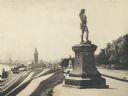
| Date: | 1895 |
|---|---|
| Description: | Side view of the statue on a plinth with Celtic designs, with his right hand holding a horn resting on his hip. The statue is located in Juneau Park. On th... |
| Date: | |
|---|---|
| Description: | Train station in the distance, with a man standing in the foreground on steps leading down to the lake, near a fenced-in pond. On the left are railroad tra... |

| Date: | 1940 |
|---|---|
| Description: | Monument in Juneau Park. A man is sitting on a bench, with Lake Michigan behind. |

| Date: | 1910 |
|---|---|
| Description: | Elevated view over trees and bushes toward the footbridge. A building with a red roof is on the far right. Beyond the bridge is Lake Michigan. Caption read... |

| Date: | |
|---|---|
| Description: | View looking down toward a curving stairway leading down to a terrace with columns and ornate railings. In the background is a flagpole on the overlook to ... |

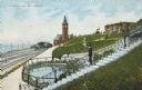
| Date: | |
|---|---|
| Description: | Elevated view of water tower and Water Tower Park with Lake Michigan in the background. Caption reads: "Water Tower and Water Tower Park, Milwaukee, Wis." |
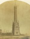
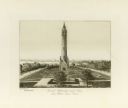
| Date: | 1870 |
|---|---|
| Description: | Water tower of the Milwaukee water works, North Point. |

| Date: | 1905 |
|---|---|
| Description: | Elevated view of Water Tower and park with Milwaukee Bay in background. Caption reads: "Water Tower and Park with view of Milwaukee Bay, Milwaukee." |
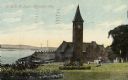
| Date: | 1910 |
|---|---|
| Description: | Chicago & Northwestern Railway Depot, with train shed and clock tower. In the foreground is a landscaped area with flowers. In the background is Lake Mich... |

| Date: | 1953 |
|---|---|
| Description: | Aerial view looking north from the foot of Milwaukee's main thoroughfare, Wisconsin Avenue. Lincoln Memorial Drive winds its way along the lagoon in Juneau... |

| Date: | 1922 |
|---|---|
| Description: | A bird's-eye map that shows the Milwaukee Parkway as contemplated by the Milwaukee County Planning Commission. The map identifies the roads and parks throu... |

| Date: | 1968 |
|---|---|
| Description: | A tourist map of Milwaukee County and of downtown Milwaukee. The Map of Milwaukee County identifies the location of some of the points of interests in the ... |

| Date: | 1914 |
|---|---|
| Description: | A hand-drawn and colored map of the Milwaukee Township, showing how lands were used, included are parks, cemeteries, private grounds, and speculative land.... |

| Date: | 1902 |
|---|---|
| Description: | Map reads: "Milwaukee's Polish Population. Map showing in Red Color the Location and Density of Polish=Speaking Population of the City of Milwaukee, Wis." ... |

| Date: | 1892 |
|---|---|
| Description: | This map shows water pipes, hydrants, stop cocks, check valves, fire cysterns, and manholes. Also shown are block numbers, streets, railroads, parks, cemet... |

| Date: | 1893 |
|---|---|
| Description: | This map covers west to Wauwatosa, north to North Milwaukee, and south to South Milwaukee and shows street railways, city limits, parks, roads, railroads, ... |

| Date: | 1910 |
|---|---|
| Description: | This ink on paper blue line print base map consists of eight separate pieces and shows city limits, The Milwaukee Electric Railroad & Light Company lines, ... |

| Date: | 1924 |
|---|---|
| Description: | This map shows streets, selected buildings, railroads, railway yards, schools, parks, schools, cemeteries, bays, the Milwaukee River, and Lake Michigan. De... |

| Date: | 1894 |
|---|---|
| Description: | This map shows sewers, intercepting sewers, manholes, block numbers, streets, railroads, parks, cemeteries, and Lake Michigan. The right margin reads: "Tot... |
If you didn't find the material you searched for, our Library Reference Staff can help.
Call our reference desk at 608-264-6535 or email us at: