 Filter: Categories of Wisconsin Historical Images
Filter: Subject of Menominee Indians
Filter: Subject of intellectual life
Filter: Categories of Wisconsin Historical Images
Filter: Subject of Menominee Indians
Filter: Subject of intellectual life
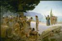
| Date: | 1904 |
|---|---|
| Description: | Jean Nicolet (1598-1642) was the first European to see Wisconsin and was a prominent French explorer who, for many years, lived among the Indians of Quebec... |
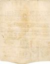
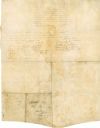
| Date: | 08 18 1821 |
|---|---|
| Description: | Green Bay Treaty, August 18, 1821. The treaty is signed by the chiefs of the six Indian nations for the possession of lands near the Fox River to the Winne... |

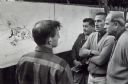
| Date: | |
|---|---|
| Description: | Pamela J. Waukau, typesetting the "Menominee Tribal News". |

| Date: | 07 1959 |
|---|---|
| Description: | Governor Gaylord Nelson signing the bill which created Menominee County as the state's 72nd county. The new county consisted of those portions of Shawano a... |
| Date: | 10 1968 |
|---|---|
| Description: | During a visit to Menominee County, Secretary of the Interior Stuart Udall and Senator Gaylord Nelson learn about a proposed resort complex. |
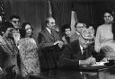
| Date: | 04 22 1975 |
|---|---|
| Description: | Secretary of the Interior Rogers Morton signing the documents that restored tribal status to the Menominee Indians. Watching the ceremony are Senator Gaylo... |
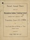
| Date: | 06 23 1908 |
|---|---|
| Description: | Menominee Training School dance card. |

| Date: | |
|---|---|
| Description: | Billhead of the Oshkosh Brewing Company, in business from 1894-1971, with the company trademark of a waist-up view of Chief Oshkosh wearing a jacket and bo... |

| Date: | |
|---|---|
| Description: | Letterhead of the Oshkosh Brewing Company, active from 1894-1971, with the company trademark of a waist-up view of Chief Oshkosh wearing a jacket, a banded... |
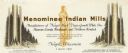
| Date: | |
|---|---|
| Description: | Letterhead of Menominee Indian Mills of Neopit, Wisconsin, a mill "under supervision of the United States Department of the Interior, Office of Indian Affa... |
| Date: | 08 18 1821 |
|---|---|
| Description: | The reverse side of the Green Bay treaty, August 18, 1821. The treaty is signed by the chiefs of the six Indian nations for the possession of lands near th... |

| Date: | 1914 |
|---|---|
| Description: | This map shows township grids, railroads, roads, and drainage. The area of the map covers northeastern Wisconsin and Menominee Indian reservation. Green Ba... |

| Date: | 1840 |
|---|---|
| Description: | This map is pencil on paper and shows rivers, granite locations, and selected landmarks. Relief is shown by hachures. |
If you didn't find the material you searched for, our Library Reference Staff can help.
Call our reference desk at 608-264-6535 or email us at: