 Filter: Categories of Wisconsin Historical Images
Filter: Subject of Menominee Indians
Filter: Creator Name of Unknown
Filter: County of Menominee
Filter: Categories of Wisconsin Historical Images
Filter: Subject of Menominee Indians
Filter: Creator Name of Unknown
Filter: County of Menominee
| Date: | |
|---|---|
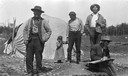
| Description: | Native Americans on the Menominee Reservation near Keshena, Wisconsin. A white man in the foreground appears to be drawing something out of camera range. T... |
| Date: | 1943 |
|---|---|
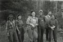
| Description: | Ribes eradication crew of Indian women on the Menominee Reservation pose together in a line. |
| Date: | |
|---|---|
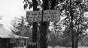
| Description: | A toll road sign on the Keshena Menominee Reservation for the Highway 55 toll road that goes through the reservation. |
| Date: | 1929 |
|---|---|
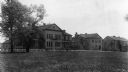
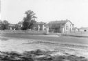
| Description: | The Government Indian School in Keshena. |
| Date: | 1929 |
|---|---|
| Description: | The U.S. Department of the Interior, Keshena Indian School. |
| Date: | |
|---|---|
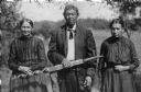
| Description: | Outdoor portrait of a Menominee Indian man and two Menominee Indian women. The man is holding a decorated ceremonial pipe in his right hand. |
| Date: | |
|---|---|
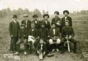
| Description: | Group portrait of the Kenshena Baseball team with a bat boy in the foreground. |
| Date: | |
|---|---|
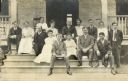
| Description: | Group portrait of eight men and seven women on the steps of the Keshena Boardinghouse. |
| Date: | |
|---|---|
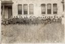
| Description: | Group portrait of Menominee Indian students and teachers in front of the Keshena Schoolhouse. |
| Date: | 07 28 1929 |
|---|---|
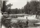
| Description: | Indian pow wow at Bear Trap Falls near Keshena. |
| Date: | 1929 |
|---|---|
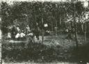
| Description: | Group of people at Bear Trap Falls in the Wolf River near Keshena. People are standing on the shoreline on the left near a sign for the falls. A man is sta... |
| Date: | |
|---|---|
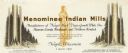
| Description: | Letterhead of Menominee Indian Mills of Neopit, Wisconsin, a mill "under supervision of the United States Department of the Interior, Office of Indian Affa... |

| Date: | 1970 |
|---|---|
| Description: | This map shows land owned by Menominee Enterprise Inc., land sold to Menominee shareholders, and land sold to non-Menominees. The map also includes water a... |
| Date: | |
|---|---|
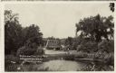
| Description: | View over water towards a road leading to a bridge. A man is standing next to an automobile on the side of the road. |
If you didn't find the material you searched for, our Library Reference Staff can help.
Call our reference desk at 608-264-6535 or email us at: