 Filter: Categories of Wisconsin Historical Images
Filter: Subject of Medicine
Filter: Subject of mississippi river
Filter: Categories of Wisconsin Historical Images
Filter: Subject of Medicine
Filter: Subject of mississippi river
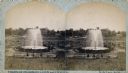
| Date: | 1880 |
|---|---|
| Description: | Stereograph of the Artesian Well near the intersection of Wisconsin and Minnesota (later renamed Wacouta) Streets. The following is printed on the back of ... |
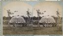
| Date: | 1880 |
|---|---|
| Description: | Stereograph of the Artesian Well near the intersection of Wisconsin and Minnesota (later renamed Wacouta) Streets. The following is printed on the backside... |
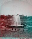
| Date: | 1880 |
|---|---|
| Description: | Stereograph of the Artesian Well near the intersection of Wisconsin and Minnesota (later renamed Wacouta) Streets. The following is printed on the back of ... |
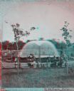
| Date: | 1880 |
|---|---|
| Description: | Stereograph of the Artesian Well near the intersection of Wisconsin and Minnesota (later renamed Wacouta) Streets. The following is printed on the backside... |

| Date: | 1912 |
|---|---|
| Description: | This map from the U.S. General Land Office shows railroads, counties, cities and villages, rivers, lakes, U.S. Land Offices, Indian reservations, military ... |

| Date: | |
|---|---|
| Description: | A hand-drawn map of Camp Curtis which was prepared for Colonel R. McMurphy. |

| Date: | 1888 |
|---|---|
| Description: | This map has relief shown by hachures and features inset maps of a plat of E.D. Clinton and Blackwell’s add’n to the City of La Crosse. Wards (1-10) shaded... |

| Date: | 1976 |
|---|---|
| Description: | This map includes an index of streets, government and historic buildings, hospitals, schools, places of recreation, churches, cemeteries, and other miscell... |
If you didn't find the material you searched for, our Library Reference Staff can help.
Call our reference desk at 608-264-6535 or email us at: