 Filter: Categories of Wisconsin Historical Images
Filter: Subject of Medicine
Filter: Subject of church buildings
Filter: Categories of Wisconsin Historical Images
Filter: Subject of Medicine
Filter: Subject of church buildings
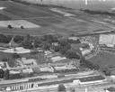
| Date: | 1958 |
|---|---|
| Description: | Aerial photograph showing the J.S. Timlin Lumber Company, 2702 University Avenue, as well as Doctors Park, the Veterans Hospital, and the First Unitarian S... |
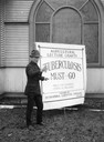
| Date: | 04 1924 |
|---|---|
| Description: | Man appearing to deliver a lecture on tuberculosis prepared by International Harvester's Agricultural Extension Department. The man is pointing to an "agri... |

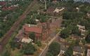
| Date: | 1950 |
|---|---|
| Description: | Aerial view of the Frank Lloyd-Wright-dsigned Unitarian Church under construction and the Veteran's Administration Hospital, also under construction, to th... |

| Date: | 1884 |
|---|---|
| Description: | Bird's-eye map of Delavan with inset of the State Institute for Deaf and Dumb. |
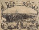
| Date: | 1864 |
|---|---|
| Description: | Bird's-eye view of Madison, with 12 vignettes and in the center is "The Capitol of Wisconsin View from the Capitol House". The buildings on the top are, fr... |
| Date: | 1959 |
|---|---|
| Description: | Aerial view of the church (built in 1928), the rectory (built in 1876), the school (built in 1958), and the convent (built in 1941). Also includes a view ... |

| Date: | 1905 |
|---|---|
| Description: | Exterior view of a church, parsonage, and hospital. Caption reads: "Catholic Church, Parsonage and Hospital, Tomahawk, Wis." |
| Date: | 1900 |
|---|---|
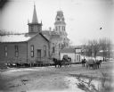
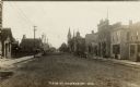
| Description: | Horse and carriages passing in front of the Baptist Church, the Jackson County Courthouse, and the dentist office of R.C. Gebhardt. |
| Date: | 1900 |
|---|---|
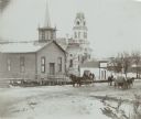
| Description: | View from across street of a dentist office and Baptist Church along a road. Two horse-drawn carriages are being driven in opposite directions on the road. |
| Date: | |
|---|---|
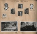
| Description: | A page from a scrapbook created by Andrew Webb Jr. when he was a patient at the Chicago Municipal Tuberculosis Sanitarium from 1931-1934, with a cut-out of... |

| Date: | 07 1982 |
|---|---|
| Description: | "Trinity United Methodist parish hall, Lomira, was the setting for the Red Cross Blood Drive." |

| Date: | 04 05 1957 |
|---|---|
| Description: | Group portrait of sixty four Madison General Hospital student nurses after their capping ceremony at the First Congregational Church. |

| Date: | 1908 |
|---|---|
| Description: | Panoramic view of Madison taken from Summit Avenue looking East South East toward Lake Monona. Included in the view are the Camp Randall bleachers, St. Rap... |
| Date: | |
|---|---|
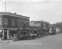
| Description: | View from intersection towards a drugstore on the left corner. A service station with a sign that says "NASH" is next door. Further down is a house and wha... |

| Date: | 1888 |
|---|---|
| Description: | This map has relief shown by hachures and features inset maps of a plat of E.D. Clinton and Blackwell’s add’n to the City of La Crosse. Wards (1-10) shaded... |

| Date: | 1976 |
|---|---|
| Description: | This map includes an index of streets, government and historic buildings, hospitals, schools, places of recreation, churches, cemeteries, and other miscell... |

| Date: | 1965 |
|---|---|
| Description: | This map shows streets, churches, schools, wards, railroads, parks and fields, cemeteries, Historical Museum, Yacht Basin & Marina, and Marinette General H... |

| Date: | 1760 |
|---|---|
| Description: | Map showing upstate New York, Lake Ontario, and the St. Lawrence River during the last, decisive battle of the French and Indian War. The main map shows a ... |

| Date: | 1789 |
|---|---|
| Description: | Map of New York City showing ward boundaries, ferries, streets, roads, swamps, ponds, and rivers. The properties of Lispinard, Byards, Jones, Rutgers, and ... |
| Date: | 1914 |
|---|---|
| Description: | Photographic postcard view down unpaved Main Street. There is a print shop and a hotel on the left, and a dentist's office and a barber shop on the right. ... |
If you didn't find the material you searched for, our Library Reference Staff can help.
Call our reference desk at 608-264-6535 or email us at: