 Filter: Categories of Wisconsin Historical Images
Filter: Subject of Marshes
Filter: Categories of Wisconsin Historical Images
Filter: Subject of Marshes

| Date: | 1975 |
|---|---|
| Description: | This standard U.S.G.S. topographic map was annotated by civil engineer and railroad historian James P. Kaysen to show the location of existing and defunct ... |

| Date: | 1902 |
|---|---|
| Description: | Catalog cover in light blue featuring an art nouveau frame in black around an illustration of ducks over marshy water with lilypads and rice plants. A red ... |
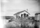
| Date: | 1910 |
|---|---|
| Description: | View across water towards a group of seven men posing on a dock in front of a small hunting shack in the middle of a marsh. Ducks hang on stringers attache... |

| Date: | 1858 |
|---|---|
| Description: | This map of Wisconsin and Minnesota shows proposed railroads, copper mines, marshes, villages, mills, reefs, notes about shorelines, and references to mini... |

| Date: | 1982 |
|---|---|
| Description: | Color map. "Topography by photogrammetric methods from aerial photographs taken 1963. Revised from aerial photographs taken 1978. Field checked 1979. Map e... |
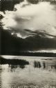
| Date: | 1905 |
|---|---|
| Description: | Photographic postcard view of Lake Metonga, with marshy area in foreground. Caption reads: "On Famous Lake Metonga, Crandon, Wis." |
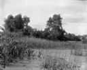
| Date: | 1899 |
|---|---|
| Description: | View over section of Turvill Marsh towards trees. On the far right in the background are what may be railroad tracks. |

| Date: | 1800 |
|---|---|
| Description: | This map is pencil on tracing paper and shows marshes, the Wisconsin River, Indian trails, and Indian boundary line. The upper left corner reads: "Let sect... |

| Date: | 1940 |
|---|---|
| Description: | Color enhanced postcard view of fisherman's shacks on the outlet of Logan's creek on the shore of Lake Michigan. |
| Date: | 1918 |
|---|---|
| Description: | Elevated view across stream in marshy area towards a group of people gathered around an aircraft wreck. |

| Date: | 1930 |
|---|---|
| Description: | Original map made with watercolor and inkwash. Includes a legend of buildings, roads, natural features and other details of the lodge. Inset at bottom has ... |

| Date: | |
|---|---|
| Description: | View across water of a Menominee man standing in a canoe in a marsh. He is holding a paddle in his hand. Behind him on the left is another canoe with three... |

| Date: | 1900 |
|---|---|
| Description: | This photostat of a manuscript map originally drawn in 1829 shows landownership, buildings, including Fort Howard and U.S. sawmill, swamps, public barns an... |

| Date: | 1911 |
|---|---|
| Description: | This map shows lakes, rivers, swamps, state swamp land, trails and railroads. Includes a township diagram. |

| Date: | 1912 |
|---|---|
| Description: | This map shows a school reserve, swamp land, railroads, and selected buildings. |

| Date: | 01 17 1980 |
|---|---|
| Description: | Vel Phillips standing outdoors wearing a coat holding binoculars. |

| Date: | 01 17 1980 |
|---|---|
| Description: | Group portrait at Horicon Marsh. Vel Phillips stands in the middle of the group wearing a coat and dark pants. The man on the far right is W. Dale Phillips... |

| Date: | |
|---|---|
| Description: | Vel Phillips, wearing a coat and a hat, stands on a gravel road with her husband, W. Dale Phillips, who is wearing a coat and eyeglasses. The marsh is in t... |

| Date: | |
|---|---|
| Description: | View through trees looking down towards a girl standing on a shoreline looking across a lake. A marshy area is along the far shoreline. |
If you didn't find the material you searched for, our Library Reference Staff can help.
Call our reference desk at 608-264-6535 or email us at:
