 Filter: Categories of Wisconsin Historical Images
Filter: Subject of Marshes
Filter: Year of 1900-1999
Filter: Year of 1970-1979
Filter: Categories of Wisconsin Historical Images
Filter: Subject of Marshes
Filter: Year of 1900-1999
Filter: Year of 1970-1979
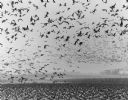
| Date: | 1972 |
|---|---|
| Description: | View of Canadian geese on the ground and in flight in Horicon Marsh. |

| Date: | 1972 |
|---|---|
| Description: | This map on 5 sheets features a title page sheet with business directory and shows section numbers, roads, railroads, saw mills, churches, blacksmith shops... |

| Date: | 1974 |
|---|---|
| Description: | This 1968 map identifies resorts in the Lac du Flambeau Indian Reservation region of Wisconsin, covering parts of Iron, Vilas, Oneida, and Price counties. ... |

| Date: | 1975 |
|---|---|
| Description: | This map shows settlers, Indian trails, roads, marshes, and forests as they appeared in 1800-1840. "A bicentennial map of Racine County for the benefit of ... |

| Date: | 1975 |
|---|---|
| Description: | This standard U.S.G.S. topographic map was annotated by civil engineer and railroad historian James P. Kaysen to show the location of existing and defunct ... |

| Date: | 1971 |
|---|---|
| Description: | A topographical map of the Grand View NW quadrangle. |

| Date: | 1975 |
|---|---|
| Description: | A family of ducks swimming across a wetlands area. In the foreground reeds extending above the waterline. |
If you didn't find the material you searched for, our Library Reference Staff can help.
Call our reference desk at 608-264-6535 or email us at:

