Filter: Categories of Wisconsin Historical Images
Filter: Subject of Marshes
Filter: Subject of transportation
Filter: Creator Name of Unknown
Filter: Categories of Wisconsin Historical Images
Filter: Subject of Marshes
Filter: Subject of transportation
Filter: Creator Name of Unknown

| Date: | 1925 |
|---|---|
| Description: | The Pierre Pauquette monument located at the easterm terminus of the Wauona Trail. Erected by the Wau-bun Chapter of the Daughters of the American Revoluti... |

| Date: | |
|---|---|
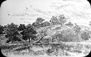
| Description: | A peaceful view of a pond and mill, featuring a small dog sitting in a boat, which rests on the shore. |
| Date: | |
|---|---|
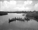
| Description: | Elevated view of a group of children, infants, and adults sitting in rowboats in the water at Manasquan Beach. In the background are rows of dwellings, and... |

| Date: | 1836 |
|---|---|
| Description: | This map is pen-and-ink on paper and shows marshlands, rivers, creeks, a quarry, and a few roads. |
| Date: | 1910 |
|---|---|
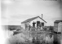
| Description: | View across water towards a group of seven men posing on a dock in front of a small hunting shack in the middle of a marsh. Ducks hang on stringers attache... |

| Date: | 1800 |
|---|---|
| Description: | This map is pencil on tracing paper and shows marshes, the Wisconsin River, Indian trails, and Indian boundary line. The upper left corner reads: "Let sect... |
| Date: | 1918 |
|---|---|
| Description: | Elevated view across stream in marshy area towards a group of people gathered around an aircraft wreck. |

| Date: | |
|---|---|
| Description: | View across water of a Menominee man standing in a canoe in a marsh. He is holding a paddle in his hand. Behind him on the left is another canoe with three... |

| Date: | 1934 |
|---|---|
| Description: | This map shows the area as it appeared in 1848 and includes buildings, land use, and roads with distances to nearby locations. The upper right corner reads... |
| Date: | |
|---|---|
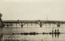
| Description: | View from shore towards a bridge crossing a river. Three boys are standing in the marshy foreground, and one of them has a fishing pole. A horse and buggy ... |

| Date: | 1789 |
|---|---|
| Description: | Map of New York City showing ward boundaries, ferries, streets, roads, swamps, ponds, and rivers. The properties of Lispinard, Byards, Jones, Rutgers, and ... |

| Date: | 1776 |
|---|---|
| Description: | Fairly detailed map of New York City and parts of Long Island. It shows streets, roads, wharves, ferries, ship yards, Fort George and the battery, public b... |

| Date: | 1779 |
|---|---|
| Description: | Map of South Carolina showing boundary lines, Native American land, precincts, townships, cities, towns, forts, roads, mountains, hills, swamps, islands, a... |

| Date: | 1779 |
|---|---|
| Description: | Map of colonial Georgia showing cities, towns, Native American land and towns, forts, roads, trading paths, islands, mountains, swamps, and rivers. Annotat... |
| Date: | 1907 |
|---|---|
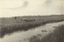
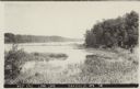
| Description: | Text on front reads: "West End, Long Lake, Saxeville, Wis." View of a lake with marshland plants in the foreground. A dock, boat and trees are on the right... |
If you didn't find the material you searched for, our Library Reference Staff can help.
Call our reference desk at 608-264-6535 or email us at: