Filter: Categories of Wisconsin Historical Images
Filter: Subject of Marshes
Filter: Subject of shorelines
Filter: Categories of Wisconsin Historical Images
Filter: Subject of Marshes
Filter: Subject of shorelines

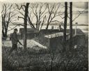
| Date: | 1904 |
|---|---|
| Description: | Monona Bay from the railroad trestle looking southwest, close to where the railroad tracks cross North Shore Drive, (now Brittingham Park), with old houses... |

| Date: | |
|---|---|
| Description: | A peaceful view of a pond and mill, featuring a small dog sitting in a boat, which rests on the shore. |
| Date: | |
|---|---|
| Description: | Elevated view of a group of children, infants, and adults sitting in rowboats in the water at Manasquan Beach. In the background are rows of dwellings, and... |

| Date: | 1836 |
|---|---|
| Description: | This map is pen-and-ink on paper and shows marshlands, rivers, creeks, a quarry, and a few roads. |

| Date: | |
|---|---|
| Description: | Elevated view from bluff overlooking the railroad tracks and yard along the Mississippi River. A group of men are gathered on the track near stacks of lumb... |

| Date: | 1858 |
|---|---|
| Description: | This map of Wisconsin and Minnesota shows proposed railroads, copper mines, marshes, villages, mills, reefs, notes about shorelines, and references to mini... |
| Date: | 1905 |
|---|---|
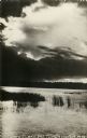
| Description: | Photographic postcard view of Lake Metonga, with marshy area in foreground. Caption reads: "On Famous Lake Metonga, Crandon, Wis." |

| Date: | 1940 |
|---|---|
| Description: | Color enhanced postcard view of fisherman's shacks on the outlet of Logan's creek on the shore of Lake Michigan. |

| Date: | |
|---|---|
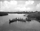
| Description: | View across water of a Menominee man standing in a canoe in a marsh. He is holding a paddle in his hand. Behind him on the left is another canoe with three... |

| Date: | |
|---|---|
| Description: | View through trees looking down towards a girl standing on a shoreline looking across a lake. A marshy area is along the far shoreline. |

| Date: | |
|---|---|
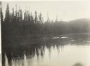
| Description: | View from shoreline over a marshy area towards a lake at Northern Lakes Park. There is a tree-covered shoreline in the far background. There may be an isl... |
| Date: | |
|---|---|
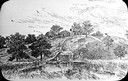
| Description: | Photograph of a watercolor painting of a hunter walking in tall grass among trees by the Johnson duck shack at old Cherokee Marsh. |

| Date: | 1795 |
|---|---|
| Description: | Map of Delaware showing counties, cities, roads, swamps, lakes, and rivers. Numerous features within the Delaware Bay include banks, shoals, and oyster be... |

| Date: | 1781 |
|---|---|
| Description: | Map of North and South Carolina and Virginia towards the end of the Revolutionary War. It shows borders, counties, cities, court houses, bridges, chapels, ... |

| Date: | 1795 |
|---|---|
| Description: | Map of South Carolina showing the precincts, cities, towns, Native American villages (marked with a triangle), courthouses, roads, mountains, swamps, islan... |

| Date: | |
|---|---|
| Description: | Watercolor painting of a hunter walking in tall grass among trees by the Johnson duck shack at old Cherokee Marsh. |

| Date: | 1761 |
|---|---|
| Description: | Map of New Orleans with north oriented towards the upper right corner. It shows the land around the city, the Mississippi River, anchorages, roads leading ... |
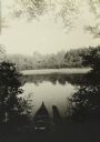
| Date: | 08 1916 |
|---|---|
| Description: | Elevated view looking down at a canoe on the shoreline of the Chippewa River as The Gang takes a well-earned rest. |
If you didn't find the material you searched for, our Library Reference Staff can help.
Call our reference desk at 608-264-6535 or email us at: