 Filter: Categories of Wisconsin Historical Images
Filter: Subject of Marshes
Filter: Subject of service industries
Filter: Categories of Wisconsin Historical Images
Filter: Subject of Marshes
Filter: Subject of service industries

| Date: | 1867 |
|---|---|
| Description: | Bird's-eye map of Green Bay and Fort Howard, Brown Co., depicts street names and street layouts, houses, trees, and the East River. A reference key at the ... |

| Date: | 1857 |
|---|---|
| Description: | This map depicts the township survey grid in Wisconsin and northern Michigan and identifies counties, named towns, cities and villages, rivers, lakes, rail... |

| Date: | 1874 |
|---|---|
| Description: | This hand-colored map of Wisconsin and the western portion of Michigan's Upper Peninsula, shows the township grid, railroads completed and in progress, cou... |

| Date: | 1878 |
|---|---|
| Description: | A hand-colored map of Wisconsin and the western portion of Michigan’s Upper Peninsula, showing the railroads that are completed and in progress, counties, ... |

| Date: | 1974 |
|---|---|
| Description: | This 1968 map identifies resorts in the Lac du Flambeau Indian Reservation region of Wisconsin, covering parts of Iron, Vilas, Oneida, and Price counties. ... |

| Date: | 1896 |
|---|---|
| Description: | This late 19th-century map of Dodge County, Wisconsin, shows the township and range grid, towns, sections, cities, villages and post offices, some property... |
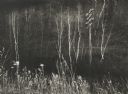
| Date: | 11 1961 |
|---|---|
| Description: | Telephone pole among marsh grasses and bare birch trees near the Spring Green Bridge. |

| Date: | 1932 |
|---|---|
| Description: | This map shows local streets, section lines, Nakoma Country Club, part of Lake Forest, and part of Lake Wingra. The map includes a legend showing areas of ... |

| Date: | 1930 |
|---|---|
| Description: | Original map made with watercolor and inkwash. Includes a legend of buildings, roads, natural features and other details of the lodge. Inset at bottom has ... |

| Date: | 1951 |
|---|---|
| Description: | This map shows land use, dwellings, resorts, camps, marshes, springs, dams, lake bottom composition, and access. The map includes a fish species table, geo... |
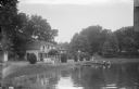
| Date: | |
|---|---|
| Description: | View across water towards a section of Sandy Beach Resort. There are people on the lawn on the left next to buildings. Two women are talking on a porch in ... |
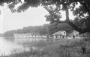
| Date: | |
|---|---|
| Description: | View from shoreline of Sandy Beach Resort. The building near the pier on the left has a sign on the roof for the resort. Along the shoreline are buildings,... |
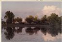
| Date: | |
|---|---|
| Description: | View of Madison from a marsh on the west end of the University of Wisconsin campus. |
If you didn't find the material you searched for, our Library Reference Staff can help.
Call our reference desk at 608-264-6535 or email us at: