Filter: Categories of Wisconsin Historical Images
Filter: Subject of Marshes
Filter: Subject of marshes
Filter: Categories of Wisconsin Historical Images
Filter: Subject of Marshes
Filter: Subject of marshes

| Date: | 1858 |
|---|---|
| Description: | Map shows township borders, marshes, pine timber, roads, railroads, and mills. The townships are are shown in blue/green, pink, and yellow. The map include... |

| Date: | 1908 |
|---|---|
| Description: | Title at top: "G.F. Sanborn Company Timber and Farming Lands." Map shows acreages, roads, railroads, and swamps in parts of Vilas and Oneida counties. |

| Date: | |
|---|---|
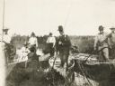
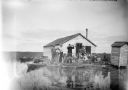
| Description: | Elevated view from bluff overlooking the railroad tracks and yard along the Mississippi River. A group of men are gathered on the track near stacks of lumb... |
| Date: | 1895 |
|---|---|
| Description: | Group of men, with women passengers, poling canoes through a marshy stretch of water on the Brule River-St. Croix River portage between Lake Superior and t... |

| Date: | |
|---|---|
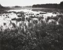
| Description: | Elevated view of the marsh and silos under a thick fog. |
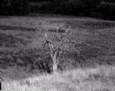
| Date: | 07 12 1964 |
|---|---|
| Description: | Dead tree at the edge of a marsh. The background fades to black. |

| Date: | 1871 |
|---|---|
| Description: | This map shows buildings, roads, the railroad, an orchard, and swamp land. Relief shown by hachures. The map includes an index of buildings in the upper ri... |
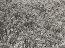
| Date: | 06 1939 |
|---|---|
| Description: | Cranberry plants in bloom at Cranmoor marsh. |
| Date: | 1938 |
|---|---|
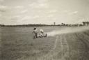
| Description: | Dusting a cranberry marsh to combat blunt-nosed leaf-hoppers, Cranberry Lake Development Co. |
| Date: | |
|---|---|
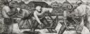
| Description: | Cranberry harvesters at work. Mural painting in the U.S. Post Office at Berlin, Wis. |
| Date: | 11 1961 |
|---|---|
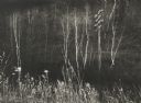
| Description: | Telephone pole among marsh grasses and bare birch trees near the Spring Green Bridge. |

| Date: | 1975 |
|---|---|
| Description: | This standard U.S.G.S. topographic map was annotated by civil engineer and railroad historian James P. Kaysen to show the location of existing and defunct ... |

| Date: | 1932 |
|---|---|
| Description: | This map shows local streets, section lines, Nakoma Country Club, part of Lake Forest, and part of Lake Wingra. The map includes a legend showing areas of ... |

| Date: | 1902 |
|---|---|
| Description: | Catalog cover in light blue featuring an art nouveau frame in black around an illustration of ducks over marshy water with lilypads and rice plants. A red ... |
| Date: | 1910 |
|---|---|
| Description: | View across water towards a group of seven men posing on a dock in front of a small hunting shack in the middle of a marsh. Ducks hang on stringers attache... |

| Date: | 1858 |
|---|---|
| Description: | This map of Wisconsin and Minnesota shows proposed railroads, copper mines, marshes, villages, mills, reefs, notes about shorelines, and references to mini... |

| Date: | 1982 |
|---|---|
| Description: | Color map. "Topography by photogrammetric methods from aerial photographs taken 1963. Revised from aerial photographs taken 1978. Field checked 1979. Map e... |
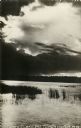
| Date: | 1905 |
|---|---|
| Description: | Photographic postcard view of Lake Metonga, with marshy area in foreground. Caption reads: "On Famous Lake Metonga, Crandon, Wis." |
If you didn't find the material you searched for, our Library Reference Staff can help.
Call our reference desk at 608-264-6535 or email us at: