 Filter: Categories of Wisconsin Historical Images
Filter: Subject of Marshes
Filter: Subject of land use
Filter: Categories of Wisconsin Historical Images
Filter: Subject of Marshes
Filter: Subject of land use
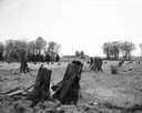
| Date: | 05 26 1963 |
|---|---|
| Description: | Burned cedar stumps in a swamp with a farm in the distance. |
| Date: | 1900 |
|---|---|
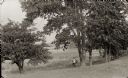
| Description: | Wetland, grassy pasture, ring fence are part of the College of Agriculture Farm on the University of Wisconsin Madison campus. |
| Date: | 1900 |
|---|---|
| Description: | A woman stands in a marsh near the site of Eleazer William's first house. |
| Date: | 1940 |
|---|---|
| Description: | Memorial to the Moravians who arrived in Eagle Bay in 1853. |
| Date: | 1907 |
|---|---|
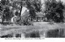
| Description: | View across water toward the Tank Cottage. Caption reads: "The Historic Tank Cottage — over 100 years old — Green Bay, Wis." |

| Date: | 1960 |
|---|---|
| Description: | View of Ennis Lake, also known as Fountain Lake, located in the John Muir Memorial Park near Montello. As a boy, John Muir lived with his family on the sho... |

| Date: | 1960 |
|---|---|
| Description: | View of Ennis Lake, also known as Fountain Lake, located in the John Muir Memorial Park near Montello. As a boy, John Muir lived with his family on the sho... |

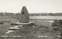
| Date: | 1925 |
|---|---|
| Description: | The Pierre Pauquette monument located at the easterm terminus of the Wauona Trail. Erected by the Wau-bun Chapter of the Daughters of the American Revoluti... |
| Date: | |
|---|---|
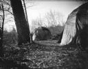
| Description: | Ho-Chunk lodges among trees. Probably a Ho-Chunk encampment at the cranberry marsh. |
| Date: | |
|---|---|
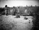
| Description: | Standing together in a row are two Ho-Chunk girls wearing print dresses, and two Ho-Chunk boys who are nude on a sandy pile in front of a marsh. In front o... |
| Date: | |
|---|---|
| Description: | A hunter is standing beneath large trees near a marsh holding a rifle. |

| Date: | 1916 |
|---|---|
| Description: | This Wisconsin Conservation Commission map from 1916 shows Peninsula State Park in the Town of Gibraltar, Door County, Wisconsin. Depicted are open and pla... |

| Date: | 1916 |
|---|---|
| Description: | This version of a 1916 Wisconsin Conservation Commission map shows Peninsula State Park in the Town of Gibraltar, Door County, Wisconsin. Depicted are open... |

| Date: | 1858 |
|---|---|
| Description: | This 1858 map of Racine County, Wisconsin, shows land ownership and acreages, the township and range grid, towns, cities and villages, roads, railroads, sc... |
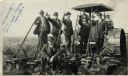
| Date: | 09 08 1914 |
|---|---|
| Description: | Five men in hats and jackets, some holding the levers on a gang plow pulled by a Rumley tractor, pose for a group portrait. One man in work clothes stands ... |

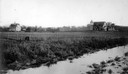
| Date: | 1914 |
|---|---|
| Description: | View of a drainage ditch in Horicon Marsh. A man is on a path along the left of the ditch. |
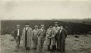
| Date: | 1914 |
|---|---|
| Description: | Group of well-dressed men standing in front of a plowed segment of Horicon Marsh. |

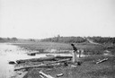
| Date: | 10 1914 |
|---|---|
| Description: | View of furrowed ground in Horicon Marsh and men on a tractor in the process of plowing a drained portion of the marsh. |
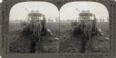
| Date: | |
|---|---|
| Description: | Stereograph showing workers digging a ditch with a tractor and laying drain tile. |

| Date: | 1908 |
|---|---|
| Description: | Title at top: "G.F. Sanborn Company Timber and Farming Lands." Map shows acreages, roads, railroads, and swamps in parts of Vilas and Oneida counties. |
If you didn't find the material you searched for, our Library Reference Staff can help.
Call our reference desk at 608-264-6535 or email us at: