Filter: Categories of Wisconsin Historical Images
Filter: Subject of Marshes
Filter: Subject of hills
Filter: Categories of Wisconsin Historical Images
Filter: Subject of Marshes
Filter: Subject of hills

| Date: | 1930 |
|---|---|
| Description: | A view looking west at Rib Mountain across the Wisconsin River from the outskirts of Wausau. |

| Date: | |
|---|---|
| Description: | Elevated view from bluff overlooking the railroad tracks and yard along the Mississippi River. A group of men are gathered on the track near stacks of lumb... |

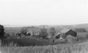
| Date: | |
|---|---|
| Description: | Elevated view of the marsh and silos under a thick fog. |

| Date: | |
|---|---|
| Description: | Elevated view from a hill of a lake or river surrounded by fields and hills. The water is either marshy, or has been flooded, as trees and plants are growi... |

| Date: | 1795 |
|---|---|
| Description: | Map of Connecticut showing counties, townships, cities, roads, islands, swamps, hills, mountains, lakes, rivers, reefs, and numerous other geographical and... |

| Date: | 11 1781 |
|---|---|
| Description: | Map of New York, Staten Island, and Long Island, showing the placements of forts, and the movement of troops in 1776. The map also includes towns, cities, ... |

| Date: | 1779 |
|---|---|
| Description: | Map of South Carolina showing boundary lines, Native American land, precincts, townships, cities, towns, forts, roads, mountains, hills, swamps, islands, a... |

| Date: | 1779 |
|---|---|
| Description: | Map of colonial Georgia showing cities, towns, Native American land and towns, forts, roads, trading paths, islands, mountains, swamps, and rivers. Annotat... |
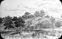
| Date: | 1935 |
|---|---|
| Description: | Elevated view from hill of chickens ranging near their coop behind a farmhouse and outbuildings on a tidy farm. There is a large barn on the right with two... |
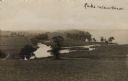
| Date: | |
|---|---|
| Description: | View of Lake Waubesa from a hill. A farm is in the distance on the left. The Yahara River is in the foreground. Handwritten caption reads: "Lake Waubesa." |

| Date: | |
|---|---|
| Description: | View down hill where grassy fields lead down to the Yahara River where it meets Lake Waubesa. Two children are walking through the grass on the left. Capti... |
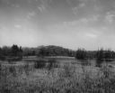
| Date: | |
|---|---|
| Description: | View across marshland and water toward a low, wooded hill. Caption reads: "Across the State of Wisconsin the continental glaciation left a belt of conspicu... |
If you didn't find the material you searched for, our Library Reference Staff can help.
Call our reference desk at 608-264-6535 or email us at: